Kipton, Ohio
| Kipton, Ohio | |
|---|---|
| Village | |
 | |
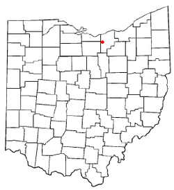 Location of Kipton, Ohio | |
 Location of Kipton in Lorain County | |
| Coordinates: 41°16′2″N 82°18′12″W / 41.26722°N 82.30333°WCoordinates: 41°16′2″N 82°18′12″W / 41.26722°N 82.30333°W | |
| Country | United States |
| State | Ohio |
| County | Lorain |
| Township | Camden |
| Government | |
| • Type | Village council |
| • Mayor | Robert Meilander |
| Area[1] | |
| • Total | 0.45 sq mi (1.17 km2) |
| • Land | 0.44 sq mi (1.14 km2) |
| • Water | 0.01 sq mi (0.03 km2) |
| Elevation[2] | 850 ft (259 m) |
| Population (2010)[3] | |
| • Total | 243 |
| • Estimate (2012[4]) | 242 |
| • Density | 552.3/sq mi (213.2/km2) |
| Time zone | UTC-5 (Eastern (EST)) |
| • Summer (DST) | UTC-4 (EDT) |
| ZIP code | 44049 |
| Area code(s) | 440 |
| FIPS code | 39-40544[5] |
| GNIS feature ID | 1064946[2] |
Kipton is a village in Lorain County, Ohio, United States. The population was 243 at the 2010 census.
History
Kipton was platted around 1852 by Wm.W.Whitney[6] in anticipation of a new railroad route being laid out through his farm. He initially named his new village "Binghamton", in honor of his former home of Binghamton, NY. However, the name "Camden Station" would instead be used until 1862, when its name was changed to "Kipton Station" (and later becoming known simply as 'Kipton').
For many years, Kipton continued as a stop along the Southern Division of the Lake Shore and Michigan Southern Railroad; however, the line was abandoned and pulled up in 1976. This former railroad route is now a part of a rail trail, the North Coast Inland Trail.
Kipton was the site of a famous train wreck on April 18, 1891,[7] which was caused by railroad engineers' watches not being in sync; and led to the adoption of stringent quality-control standards for railroad chronometers in 1893.
Geography
Kipton is located at 41°16′2″N 82°18′12″W / 41.26722°N 82.30333°W (41.267101, -82.303337).[8]
According to the United States Census Bureau, the village has a total area of 0.45 square miles (1.17 km2), of which 0.44 square miles (1.14 km2) is land and 0.01 square miles (0.03 km2) is water.[1]
Demographics
| Historical population | |||
|---|---|---|---|
| Census | Pop. | %± | |
| 1960 | 353 | — | |
| 1970 | 353 | 0.0% | |
| 1980 | 352 | −0.3% | |
| 1990 | 283 | −19.6% | |
| 2000 | 265 | −6.4% | |
| 2010 | 243 | −8.3% | |
| Est. 2017 | 236 | [9] | −2.9% |
| U.S. Decennial Census[10] | |||
2010 census
As of the census[3] of 2010, there were 243 people, 102 households, and 72 families residing in the village. The population density was 552.3 inhabitants per square mile (213.2/km2). There were 108 housing units at an average density of 245.5 per square mile (94.8/km2). The racial makeup of the village was 97.1% White, 0.8% from other races, and 2.1% from two or more races. Hispanic or Latino of any race were 2.5% of the population.
There were 102 households of which 25.5% had children under the age of 18 living with them, 54.9% were married couples living together, 9.8% had a female householder with no husband present, 5.9% had a male householder with no wife present, and 29.4% were non-families. 24.5% of all households were made up of individuals and 9.8% had someone living alone who was 65 years of age or older. The average household size was 2.38 and the average family size was 2.79.
The median age in the village was 42.8 years. 19.3% of residents were under the age of 18; 9.1% were between the ages of 18 and 24; 23.9% were from 25 to 44; 32.5% were from 45 to 64; and 15.2% were 65 years of age or older. The gender makeup of the village was 54.7% male and 45.3% female.
2000 census
As of the census[5] of 2000, there were 265 people, 105 households, and 76 families residing in the village. The population density was 573.2 people per square mile (222.4/km²). There were 108 housing units at an average density of 233.6 per square mile (90.7/km²). The racial makeup of the village was 98.49% White, 0.75% African American, and 0.75% from two or more races. Hispanic or Latino of any race were 0.38% of the population.
There were 105 households out of which 32.4% had children under the age of 18 living with them, 58.1% were married couples living together, 10.5% had a female householder with no husband present, and 26.7% were non-families. 22.9% of all households were made up of individuals and 9.5% had someone living alone who was 65 years of age or older. The average household size was 2.52 and the average family size was 2.92.
In the village, the population was spread out with 24.9% under the age of 18, 9.8% from 18 to 24, 31.7% from 25 to 44, 20.4% from 45 to 64, and 13.2% who were 65 years of age or older. The median age was 38 years. For every 100 females there were 113.7 males. For every 100 females age 18 and over, there were 109.5 males.
The median income for a household in the village was $48,182, and the median income for a family was $44,375. Males had a median income of $46,250 versus $22,188 for females. The per capita income for the village was $19,499. About 2.4% of families and 4.5% of the population were below the poverty line, including 8.3% of those under the age of eighteen and 7.7% of those sixty five or over.
References
- 1 2 "US Gazetteer files 2010". United States Census Bureau. Archived from the original on 2012-07-14. Retrieved 2013-01-06.
- 1 2 "US Board on Geographic Names". United States Geological Survey. 2007-10-25. Retrieved 2008-01-31.
- 1 2 "American FactFinder". United States Census Bureau. Retrieved 2013-01-06.
- ↑ "Population Estimates". United States Census Bureau. Archived from the original on 2013-06-17. Retrieved 2013-06-17.
- 1 2 "American FactFinder". United States Census Bureau. Retrieved 2008-01-31.
- ↑ Overman, William Daniel (1958). Ohio Town Names. Akron, OH: Atlantic Press. p. 70.
- ↑ "The Great Kipton Train Wreck". National Postal Museum. Retrieved 2016-02-20.
- ↑ "US Gazetteer files: 2010, 2000, and 1990". United States Census Bureau. 2011-02-12. Retrieved 2011-04-23.
- ↑ "Population and Housing Unit Estimates". Retrieved May 26, 2018.
- ↑ "Census of Population and Housing". Census.gov. Archived from the original on May 12, 2015. Retrieved June 4, 2015.
Municipalities and communities of Lorain County, Ohio, United States | ||
|---|---|---|
| Cities |  | |
| Villages | ||
| Townships | ||
| CDPs | ||
| Unincorporated communities | ||
| Ghost town | ||
| Footnotes | ‡This populated place also has portions in an adjacent county or counties | |