Kings Canyon (Utah)
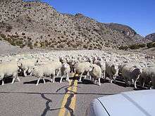
Sheep herded along the road through the canyon
Kings Canyon is a canyon within the Confusion Range in Millard County, Utah. US Highway 6/US Highway 50 runs through the windy canyon. The area in and around the canyon is unpopulated, and is only used by humans for transportation and some sheep herding.
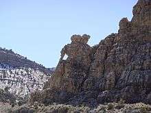
Elephant Rock
The strongly bedded rocks that line the canyon are chiefly Silurian to Devonian carbonate rocks,[1] though pink Tertiary ignimbrites can also be seen sporadically in places. A side spur of the canyon, called Cat Canyon, is the location of the most famous tourist attraction in the canyon,[2] Elephant Rock which is in the shape of an elephant carrying a pack or load.
References
- ↑ Chronic, H., 1990, Roadside Geology of Utah, ISBN 0-87842-228-5
- ↑ User, Super. "Elephant Rock - Millard County Travel". www.millardcounty.com. Retrieved 5 June 2017.
Coordinates: 39°05′10″N 113°33′35″W / 39.08611°N 113.55972°W
This article is issued from
Wikipedia.
The text is licensed under Creative Commons - Attribution - Sharealike.
Additional terms may apply for the media files.