King Lud's Entrenchments and The Drift
| Site of Special Scientific Interest | |
 | |
| Area of Search |
Leicestershire Lincolnshire |
|---|---|
| Grid reference | SK 864 282 [1] |
| Interest | Biological |
| Area | 23.9 hectares (59 acres)[1] |
| Notification | 1984[1] |
| Location map | Magic Map |
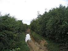
King Lud's Entrenchments and The Drift is a 23.9 hectares (59 acres) biological Site of Special Scientific Interest which straddles the border between Lincolnshire and Leicestershire, and is east of Croxton Kerrial.[1][2] King Lud's Entrenchments is a Scheduled Ancient Monument.[3]
This site has limestone grassland with tor-grass, cock's foot, crested dog's-tail and red fescue. Herbs include salad burnet, field scabious, germander speedwell and perforate St John's-wort, and there is also some broad-leaved semi-natural woodland.[4]
There is access to the site and The Drift is part of the Viking Way long distance trail.
References
- 1 2 3 4 "Designated Sites View: King Lud's Entrenchments and The Drift". Sites of Special Scientific Interest. Natural England. Retrieved 13 November 2017.
- ↑ "Map of King Lud's Entrenchments and The Drift". Sites of Special Scientific Interest. Natural England. Retrieved 13 November 2017.
- ↑ "King Lud's Intrenchments and adjacent barrow". Historic England. Retrieved 8 August 2017.
- ↑ "King Lud's Entrenchments and The Drift citation" (PDF). Sites of Special Scientific Interest. Natural England. Retrieved 13 November 2017.
| Wikimedia Commons has media related to King Lud's Entrenchments and The Drift. |
This article is issued from
Wikipedia.
The text is licensed under Creative Commons - Attribution - Sharealike.
Additional terms may apply for the media files.