King-Lebel
| King-Lebel | |
|---|---|
| designated place | |
 King Kirkland | |
| Coordinates: 48°09′45″N 79°57′30″W / 48.16250°N 79.95833°WCoordinates: 48°09′45″N 79°57′30″W / 48.16250°N 79.95833°W | |
| Country |
|
| Province |
|
| District | Timiskaming District |
| Government | |
| • Type | local services board |
| • MP | Charlie Angus |
| • MPP | John Vanthof |
| Area | |
| • Total | 83.92 km2 (32.40 sq mi) |
| Population (2016) | |
| • Total | 379 |
| • Density | 4.5/km2 (12/sq mi) |
| Canada 2016 Census | |
| Time zone | UTC-5 (Eastern (EST)) |
| Area code(s) | 705 |
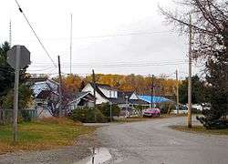
King-Lebel is a designated place in the Canadian province of Ontario, located in the Timiskaming District. The community, located between the town of Kirkland Lake and the municipal township of Gauthier, consists of the unincorporated township of Lebel, whose primary settlement is the community of King Kirkland.
Services in the township are provided by a local services board.
King-Lebel had a population of 379 in the Canada 2016 Census.[1][2] The community is considered part of Timiskaming, Unorganized, West Part.
| Historical population | ||
|---|---|---|
| Year | Pop. | ±% |
| 2006 | 351 | — |
| 2011 | 322 | −8.3% |
| 2016 | 376 | +16.8% |
References
- ↑ Population and dwelling counts, for Canada, provinces and territories, and designated places, 2006 and 2001 censuses - 100% data
- ↑ http://www12.statcan.gc.ca/census-recensement/2011/dp-pd/prof/details/page.cfm?Lang=E&Geo1=DPL&Code1=350032&Geo2=PR&Code2=01&Data=Count&SearchText=King-Lebel&SearchType=Begins&SearchPR=01&B1=All&Custom=&TABID=1
Places adjacent to King-Lebel | ||||||||||
|---|---|---|---|---|---|---|---|---|---|---|
| ||||||||||
| City |  | |
|---|---|---|
| Towns | ||
| Townships | ||
| Village | ||
| Indian Reserves | ||
| Unorganized areas | ||
| Local services boards | ||
| ||
This article is issued from
Wikipedia.
The text is licensed under Creative Commons - Attribution - Sharealike.
Additional terms may apply for the media files.