Kholm, Kholmsky District, Novgorod Oblast
| Kholm Холм (Russian) | |
|---|---|
| - Town[1] - | |
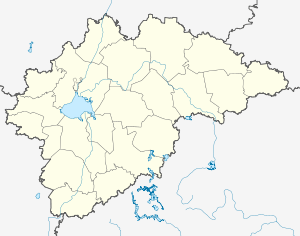
.svg.png) Location of Novgorod Oblast in Russia | |
 Kholm | |
_(1781).png) | |
|
Coat of arms | |
| Administrative status (as of April 2014) | |
| Country | Russia |
| Federal subject | Novgorod Oblast[1] |
| Administrative district | Kholmsky District[1] |
| Town of district significance | Kholm[2] |
| Administrative center of | Kholmsky District,[1] town of district significance of Kholm[2] |
| Municipal status (as of September 2010) | |
| Municipal district | Kholmsky Municipal District[3] |
| Urban settlement | Kholmskoye Urban Settlement[4] |
| Administrative center of | Kholmsky Municipal District,[3] Kholmskoye Urban Settlement[4] |
| Statistics | |
| Population (2010 Census) | 3,830 inhabitants[5] |
| Time zone | MSK (UTC+03:00)[6] |
| First mentioned | 1144[7] |
| Town status since | 1777[7] |
| Previous names | Kholmsky pogost (until 1777) |
| Postal code(s)[8] | 175270, 175271 |
| Kholm on Wikimedia Commons | |
Kholm (Russian: Холм) is a town and the administrative center of Kholmsky District in Novgorod Oblast, Russia, located at the confluence of the Lovat and Kunya Rivers, 77 kilometers (48 mi) north of Toropets, 93 kilometers (58 mi) southwest of Staraya Russa, and 201 kilometers (125 mi) south of Veliky Novgorod, the administrative center of the oblast. Population: 3,830 (2010 Census);[5] 4,325 (2002 Census);[9] 4,849 (1989 Census).[10]
History
The Lovat River was a part of the trade route from the Varangians to the Greeks, one of the oldest trading routes passing through Rus'. The settlement was first mentioned in 1144[7] as Kholmsky pogost (Холмский погост). During the Middle Ages, the town, then a seat of the Princes of Kholm, withstood innumerable sieges by Lithuanians, Poles, and Swedes.
In 1777, it was elevated in status to that of an uyezd town[7] of Pskov Viceroyalty and given its present name. In 1796, it was transferred to Pskov Governorate.[7] In August 1927, the uyezds were abolished and, effective October 1, 1927, Kholmsky District was established, with the administrative center in Kholm.[11] Pskov Governorate was abolished as well and the district became a part of Velikiye Luki Okrug of Leningrad Oblast.[11] On June 3, 1929, Velikiye Luki Okrug was transferred to Western Oblast.[12] On July 23, 1930 the okrugs were abolished and the districts were directly subordinated to the oblast.[12] On January 29, 1935, the district became a part of the newly established Kalinin Oblast.
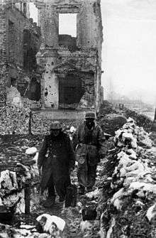
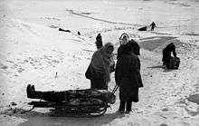
During World War II, it was occupied by the Wehrmacht from August 3, 1941 to February 21, 1944, when it was liberated. It was the scene of the Kholm Pocket from January 21 to May 5, 1942. The town was completely ruined and even now its current population is only a third of the pre-war one.
On July 5, 1944, the district was included in newly established Novgorod Oblast, but already on August 22, 1944 it was transferred to newly established Velikiye Luki Oblast.[13] On October 2, 1957, Velikiye Luki Oblast was abolished and Kholmsky District was transferred to Pskov Oblast.[14] On July 29, 1958, it was transferred to Novgorod Oblast and remained there ever since.[7][14]
Administrative and municipal status
Within the framework of administrative divisions, Kholm serves as the administrative center of Kholmsky District.[1] As an administrative division, it is incorporated within Kholmsky District as the town of district significance of Kholm.[2] As a municipal division, the town of district significance of Kholm is incorporated within Kholmsky Municipal District as Kholmskoye Urban Settlement.[4]
Economy
Industry
The economy of Kholm and its district is based on timber industry.[15]
Transportation
Kholm is connected by roads to Staraya Russa, to Bezhanitsy, to Demyansk via Maryovo, and to Toropets.
The Lovat and the Kunya Rivers are not navigable in Kholm.
Culture and recreation
Kholm contains eight monuments classified as cultural and historical heritage of local significance.[16] Seven of them are graves of and monuments to soldiers fallen in World War II, while the eighth one is an archaeological site.
In the dense woods and impracticable swamps to the west of Kholm lies the deserted Rdeysky Monastery.[17]
Kholm hosts the Kholmsky District Museum which was opened in 1983.[18]
References
Notes
- 1 2 3 4 5 Law #559-OZ
- 1 2 3 Resolution #121
- 1 2 Law #284-OZ
- 1 2 3 Law #353-OZ
- 1 2 Russian Federal State Statistics Service (2011). "Всероссийская перепись населения 2010 года. Том 1" [2010 All-Russian Population Census, vol. 1]. Всероссийская перепись населения 2010 года (2010 All-Russia Population Census) (in Russian). Federal State Statistics Service. Retrieved June 29, 2012.
- ↑ Правительство Российской Федерации. Федеральный закон №107-ФЗ от 3 июня 2011 г. «Об исчислении времени», в ред. Федерального закона №271-ФЗ от 03 июля 2016 г. «О внесении изменений в Федеральный закон "Об исчислении времени"». Вступил в силу по истечении шестидесяти дней после дня официального опубликования (6 августа 2011 г.). Опубликован: "Российская газета", №120, 6 июня 2011 г. (Government of the Russian Federation. Federal Law #107-FZ of June 31, 2011 On Calculating Time, as amended by the Federal Law #271-FZ of July 03, 2016 On Amending Federal Law "On Calculating Time". Effective as of after sixty days following the day of the official publication.).
- 1 2 3 4 5 6 Энциклопедия Города России. Moscow: Большая Российская Энциклопедия. 2003. p. 506. ISBN 5-7107-7399-9.
- ↑ Почта России. Информационно-вычислительный центр ОАСУ РПО. (Russian Post). Поиск объектов почтовой связи (Postal Objects Search) (in Russian)
- ↑ Russian Federal State Statistics Service (May 21, 2004). "Численность населения России, субъектов Российской Федерации в составе федеральных округов, районов, городских поселений, сельских населённых пунктов – районных центров и сельских населённых пунктов с населением 3 тысячи и более человек" [Population of Russia, Its Federal Districts, Federal Subjects, Districts, Urban Localities, Rural Localities—Administrative Centers, and Rural Localities with Population of Over 3,000] (XLS). Всероссийская перепись населения 2002 года [All-Russia Population Census of 2002] (in Russian). Retrieved August 9, 2014.
- ↑ Demoscope Weekly (1989). "Всесоюзная перепись населения 1989 г. Численность наличного населения союзных и автономных республик, автономных областей и округов, краёв, областей, районов, городских поселений и сёл-райцентров" [All Union Population Census of 1989: Present Population of Union and Autonomous Republics, Autonomous Oblasts and Okrugs, Krais, Oblasts, Districts, Urban Settlements, and Villages Serving as District Administrative Centers]. Всесоюзная перепись населения 1989 года [All-Union Population Census of 1989] (in Russian). Институт демографии Национального исследовательского университета: Высшая школа экономики [Institute of Demography at the National Research University: Higher School of Economics]. Retrieved August 9, 2014.
- 1 2 Snytko et al., p. 85
- 1 2 Snytko et al., p. 87
- ↑ Snytko et al., p. 93
- 1 2 Snytko et al., p. 240
- ↑ Холмский район (in Russian). Администрация Холмского муниципального района. 2012. Retrieved March 2, 2012.
- ↑ Памятники истории и культуры народов Российской Федерации (in Russian). Russian Ministry of Culture. Retrieved 2 June 2016.
- ↑ Rdeysky Monastery
- ↑ Музей Холмского района (in Russian). МУК "Музей истории Холмского района". Archived from the original on May 12, 2012. Retrieved March 3, 2012.
Sources
- Снытко, О. В. (2009). С. Д. Трифонов; Т. Б. Чуйкова; Л. В. Федина; А. Э. Дубоносова, eds. Административно-территориальное деление Новгородской губернии и области 1727-1995 гг. Справочник (PDF) (in Russian). St. Petersburg. Retrieved May 22, 2014.
- Новгородская областная Дума. Областной закон №559-ОЗ от 11 ноября 2005 г. «Об административно-территориальном устройстве Новгородской области», в ред. Областного закона №730-ОЗ от 26 февраля 2015 г. «О внесении изменений в Областной закон "Об административно-территориальном устройстве Новгородской области"». Вступил в силу 1 января 2006 г. Опубликован: "Новгородские ведомости", №75, 23 ноября 2005 г. (Novgorod Oblast Duma. Oblast Law #559-OZ of November 11, 2005 On the Administrative-Territorial Structure of Novgorod Oblast, as amended by the Oblast Law #730-OZ of February 26, 2015 On Amending the Oblast Law "On the Administrative-Territorial Structure of Novgorod Oblast". Effective as of January 1, 2006.).
- Администрация Новгородской области. Постановление №121 от 8 апреля 2008 г. «Об реестре административно-территориального устройства области», в ред. Постановления №408 от 4 августа 2014 г. «О внесении изменений в реестр административно-территориального устройства области». Опубликован: "Новгородские ведомости", №49–50, 16 апреля 2008 г. (Administration of Novgorod Oblast. Resolution #121 of April 8, 2008 On the Registry of the Administrative-Territorial Structure of Novgorod Oblast, as amended by the Resolution #408 of August 4, 2014 On Amending the Registry of the Administrative-Territorial Structure of Novgorod Oblast. ).
- Новгородская областная Дума. Областной закон №284-ОЗ от 7 июня 2004 г. «О наделении сельских районов и города Великий Новгород статусом муниципальных районов и городского округа Новгородской области и утверждении границ их территорий», в ред. Областного закона №802-ОЗ от 31 августа 2015 г. «О внесении изменений в некоторые областные Законы, устанавливающие границы муниципальных образований». Вступил в силу со дня, следующего за днём официального опубликования. Опубликован: "Новгородские ведомости", №86, 22 июня 2004 г. (Novgorod Oblast Duma. Oblast Law #284-OZ of June 7, 2004 On Granting the Status of Municipal Districts and Urban Okrug of Novgorod Oblast to the Rural Districts and the City of Veliky Novgorod and on Establishing the Borders of Their Territories, as amended by the Oblast Law #802-OZ of August 31, 2015 On Amending Various Oblast Laws Establishing the Borders of the Municipal Formations. Effective as of the day following the day of the official publication.).
- Новгородская областная Дума. Областной закон №353-ОЗ от 2 декабря 2004 г. «Об установлении границ муниципальных образований, входящих в состав территории Холмского муниципального района, наделении их статусом городских и сельских поселений, определении административных центров и перечня населённых пунктов, входящих в состав территорий поселений», в ред. Областного закона №216-ОЗ от 1 марта 2013 г. «О внесении изменений в некоторые Областные законы, содержащие перечни населённых пунктов, входящих в состав территорий поселений». Вступил в силу со дня, следующего за днём официального опубликования. Опубликован: "Новгородские ведомости", №79, 8 декабря 2004 г. (Novgorod Oblast Duma. Oblast Law #353-OZ of December 2, 2004 On Establishing the Borders of the Municipal Formations Within the Territory of Kholmsky Municipal District, on Granting Them the Status of Urban and Rural Settlements, on Establishing Their Administrative Centers, and on Compiling the Lists of Inhabited Localities Within the Settlement Territories, as amended by the Oblast Law #216-OZ of March 1, 2013 On Amending Various Oblast Laws Containing the Registries of the Inhabited Localities on the Territories of the Settlements. Effective as of the day following the day of the official publication.).
| Districts | |||
|---|---|---|---|
| Cities and towns | |||
| Urban-type settlements | |||