Khlong Bangkok Yai
.jpg)
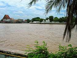
Khlong Bangkok Yai (Thai: คลองบางกอกใหญ่; lit: Bangkok Yai Canal) is a historic khlong (คลอง; canal) of Bangkok. Originally it was part of the Chao Phraya River, In the past, Chao Phraya River has a more tortuous condition than present. Those who travel by boat must cruise along the river, which takes more than one day. It's a waste of time. Until in the reign of King Chairachathirat (1534–46) of Ayutthaya Kingdom, he ordered to be canalize through the mid of Chao Phraya River, reduce travel time faster, named Khlong Lat Bangkok (คลองลัดบางกอก; Bangkok Short-Cut Canal), and make the original Chao Phraya River become two canals are Khlong Bangkok Yai (lower) and Khlong Bangkok Noi (upper) until today.
In the reign of King Taksin (1767–82) of Thonburi Kingdom, he founded a new capital on the west side of the Chao Phraya River. So, throughout the Khlong Bangkok Yai became the residence of many people, such as the nobility and the citizen, and it was named Khlong Bang Luang or Khlong Bang Kha Luang (คลองบางหลวง, คลองบางข้าหลวง; Canal of Governor). And it's the first canal in Thailand with lampposts installed as well. It's currently 6 km (about 3 mi) long passes through Bangkok Yai and Phasi Charoen with Thon Buri Districs .[1] [2]
In addition, its name also became the current name of Bangkok, same as the counterpart, Khlong Bangkok Noi. Assumed to have meaning "Hamlet of Olives", due to in the past, they flourished along waterways in the area.[1]
Khlong Bangkok Yai is now a waterway and drainage. It is also an one major cultural tourism of Bangkok[3]. There are many houses of worship on both sides, such as Wat Molilokayaram, Wat Hongratanaram, Wat Nuannoradit, Wat Kalayanamitr, Wat Paknam Bhasicharoen, Wat Kuhasawan, Bang Luang Mosque, Tonson Mosque, Kudi Charoenphat etc., including historic places such as Khlong Bang Luang Artist House[3], Talat Phlu or Wichai Prasit Fort.
See also
- Khlong Bangkok Noi– counterpart canal
References
- 1 2 "พินิจนคร (Season 1) ตอน ธนบุรี 1". TPBS (in Thai). 2009-02-09.
- ↑ "พินิจนคร (Season2) ตอน คลองบางหลวง". TPBS (in Thai). 2009-11-30.
- 1 2 ""ชุมชนริมคลองบางหลวง" สัมผัสวิถีชีวิตดั้งเดิมกับงานศิลป์ทรงคุณค่า". Manager Daily (in Thai). 2018-04-06.
| Wikimedia Commons has media related to Khlong Bangkok Yai. |
Coordinates: 13°46′45.3″N 100°27′46.6″E / 13.779250°N 100.462944°E