Khartoum North
| Khartoum North الخرطوم بحري | |
|---|---|
| City | |
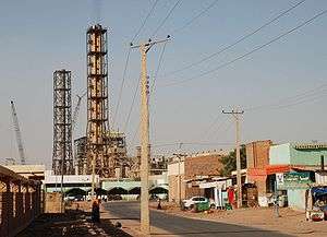 Industrial area of Khartoum North | |
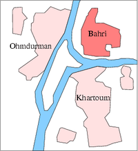
| Nickname(s): Bahri | |
| Country |
|
| Population | +900,000 |
Khartoum North or Bahri (Arabic: الخرطوم بحري, al-Kharṭūm Baḥrī) is the third-largest city in the Republic of Sudan. It is located on the north bank of the Blue Nile and east bank of River Nile near its confluence with the White and bridges connect it with Khartoum to its south and Omdurman to its west.
It is thought to have a population of over a million, but the last Sudanese census occurred in 1993 when its population was only 900,000.
Demographics
| Year | Population[1][2] |
|---|---|
| 1956 | 39,100 |
| 1973 | 150,989 |
| 1983 | 341,155 |
| 1993 | 700,887 |
| 2007 estimate | 1,725,570 |
History
The original settlement at Khartoum North, Halfaya, was long the largest settlement in the area of the Nile confluence before the Egyptians established Khartoum as their military garrison and administrative center in the 1820s.[3] It was thereafter eclipsed by the Egyptian Khartoum, its Mahdist replacement Omdurman, and the British refounding of Khartoum following their reconquest of the country in 1898. Khartoum North began to grow again, however, as the southern terminus of the Sudan Military Railroad, which was completed in 1899.[3] (The Blue Nile was bridged in 1910 and the line extended to Sennar, but Khartoum North continued to serve as the main railroad station and yard.)
On August 20, 1998 the Al-Shifa pharmaceutical factory was destroyed by a cruise missile because the United States accused the factory of making VX (nerve agent) for al-Qaeda.[4][5][6]
Economy and industry
The industrial centre of the region and the country, the city contains dockyards, marine and rail workshops, and sawmills. Khartoum North trades in cotton, grains, fruit, and livestock; industries include tanning, brewing, brickmaking, textile weaving, and food processing. Since the year 2000, chemical plants supplying household products to the rest of the country have been built in the city.
A wealthy suburb is growing towards the eastern part of the city, along the Blue Nile.
Neighbourhoods
Khartoum North has many neighbourhoods, some of which are:
- Alamlaak
- Copper City
- Kafouri
- Bahri Industrial Area
- Al Haj Yousif
- Al Sababi
- Al Dnagla North
- Al Dnagla South
- Hilat Hamad
- Hilat Khojali
- Hilat Koko
- Greaf Sharq
- Alshabia North
- Alshabia South
- Almazad
- Almulazmien
- Almerghania
- Alsafia
- Shambat
- Khoglab
- Alqadisia
Infrastructure
Bridges
The following bridges cross the Blue Nile and connect Khartoum North to Khartoum:
- Mac Nimir Bridge
- Blue Nile Road and Railway Bridge
- Cooper Bridge
- Al Mansheiya Bridge
- Shambat Bridge crosses the Nile and connects the city to Omdurman
References
- ↑ Archived September 30, 2007, at the Wayback Machine.
- ↑ Archived October 19, 2007, at the Wayback Machine.
- 1 2 "

- ↑ Astill, James (October 2, 2001). "Strike one". London: The Guardian.
- ↑ "US Destruction of Al Shifa Factory 14th Anniversary". Sudanese embassy in Washington, DC. Archived from the original on 2013-01-17.
- ↑ Peterson, Scott. "Sudanese factory destroyed by US now a shrine". Christian Science Monitor.
Coordinates: 15°38′N 32°38′E / 15.633°N 32.633°E