Kharpahlu
| Kharpahlu خارپهلو | |
|---|---|
| village | |
 village overview | |
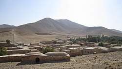
 Kharpahlu | |
| Coordinates: 34°15′56″N 49°31′30″E / 34.26556°N 49.52500°ECoordinates: 34°15′56″N 49°31′30″E / 34.26556°N 49.52500°E | |
| Country |
|
| Province | Markazi |
| County | Khondab |
| Bakhsh | Qareh Chay |
| Rural District | Javersiyan |
| Population (2006) | |
| • Total | 134 |
| Time zone | UTC+3:30 (IRST) |
| • Summer (DST) | UTC+4:30 (IRDT) |
Kharpahlu (Persian: خارپهلو, also Romanized as Khārpahlū)[1] is a village in Javersiyan Rural District, Qareh Chay District, Khondab County, Markazi Province, Iran. At the 2006 census, its population was 134, in 33 families.[2]
References
- ↑ Kharpahlu can be found at GEOnet Names Server, at this link, by opening the Advanced Search box, entering "-3805276" in the "Unique Feature Id" form, and clicking on "Search Database".
- ↑ "Census of the Islamic Republic of Iran, 1385 (2006)". Islamic Republic of Iran. Archived from the original (Excel) on 2011-11-11.
| Capital | |||||||||||||||||||||||
|---|---|---|---|---|---|---|---|---|---|---|---|---|---|---|---|---|---|---|---|---|---|---|---|
| Districts |
| ||||||||||||||||||||||
This article is issued from
Wikipedia.
The text is licensed under Creative Commons - Attribution - Sharealike.
Additional terms may apply for the media files.