Kharaa River
| Kharaa River (Хараа гол) | |
| River | |
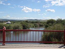 Kharaa River from Baruunkharaa bridge | |
| Country | |
|---|---|
| Aimags | Töv, Selenge, Darkhan-Uul |
| Major cities | Züünkharaa, Darkhan |
| Tributaries | |
| - right | Tünkhel River |
| Source confluence | Sögnögör River, Mandal River |
| - location | Batsümber sum, Töv aimag |
| - coordinates | 48°26′4″N 106°45′58″E / 48.43444°N 106.76611°E |
| Mouth | Orkhon River |
| - location | Orkhon sum, Darkhan-Uul aimag |
| - coordinates | 49°37′30″N 105°50′30″E / 49.62500°N 105.84167°ECoordinates: 49°37′30″N 105°50′30″E / 49.62500°N 105.84167°E |
| Length | 291 km (181 mi) |
| Basin | 15,000 km2 (5,792 sq mi) |
| Discharge | for Baruunkharaa |
| - average | 8.3 m3/s (293 cu ft/s) |
| - max | 99.3 m3/s (3,507 cu ft/s) |
Kharaa River (Mongolian: Хараа гол) is a river in central northern Mongolia. It starts in a confluence between Sögnögör River and Mandal River near the center of Batsümber sum in Töv aimag,[1] and then continues in a roughly north-western direction through Selenge aimag. On the last stretch it flows through the Darkhan-Uul aimag, running along its western border and passing the city of Darkhan before entering the Orkhon River near the northern tip of the aimag.[2]
See also
References
- ↑ "Russian army map "100k--m48-130"". Maps for the world. Retrieved 2015-01-05.
- ↑ "Russian army map "100k--m48-092"". Maps for the world. Retrieved 2015-01-05.
This article is issued from
Wikipedia.
The text is licensed under Creative Commons - Attribution - Sharealike.
Additional terms may apply for the media files.