Khenifra
| Khenifra Xnifṛa ⵅⵏⵉⴼⵕⴰ خنيفرة | |
|---|---|
    | |
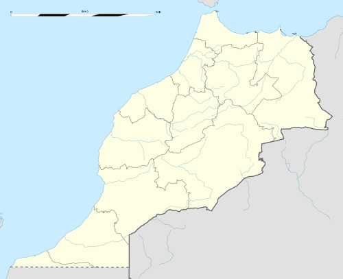 Khenifra Location in Morocco | |
| Coordinates: 32°56′22″N 5°40′3″W / 32.93944°N 5.66750°W | |
| Country |
|
| Region | Béni Mellal-Khénifra |
| Province | Khenifra |
| Population (2014)[1] | |
| • Total | 117,510 |
| Time zone | UTC+0 (WET) |
| • Summer (DST) | UTC+1 (WEST) |
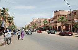
Khenifra (Berber: Xnifṛa, ⵅⵏⵉⴼⵕⴰ, Arabic: خنيفرة) is a city in northern central Morocco, surrounded by the Atlas Mountains and located on the Oum Er-Rbia River. National Highway 8 also goes through the town. The population, as of a 2014 census, was 117,510.
History
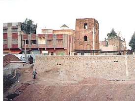
Khenifra has been the Zayanes' central town for centuries. As such, it was an important military holding in the Zaian War. French General Paul Prosper Henrys had planned to lead the first attack on Khenifra on 10 June 1914. There would be three columns of troops, totaling up to 14,000 officers, to take Khenifra from the Zayanes control.[2] One column was under Lieutenant-Colonel Henri Claudel, one under Colonel Gaston Cros, and one under Colonel Noël Garnier-Duplessix.[3] Mouha ou Hammou Zayani led troops to attempt to stop the Khenifra campaign, but was eventually unsuccessful.[4] The French took control of the town, but with losing around 600 men.[5] In addition to leading the Zayanes, Hammou was responsible for much of the early 20th century development of Khenifra, having overseen the development of accommodations and mosques in the town.[6]
Demography
Khenifra is inhabited by Zayanes, a Berber tribe, and the language spoken is a variety of Central Atlas Tamazight.[7] The town population at the time of the 2014 census was 117,510.[1]
Geography
Khenifra is located on the Oum Er-Rbia River[8] National Highway 8 goes through Khenifra, and can provide travel to Marrakech and Fès.[9] Jebel Bououzzal, "Iron Mountain", provides a source of iron, but its usefulness is limited due to also having a high sulphur content.[10] Khenifra National Park is east of the town, and contains forests of Atlas cedars (Cedrus atlantica).
Sports
Khenifra has a football club, Chabab Atlas Khénifra. In addition to a men's team, the club established a women's squad on 30 November 1998.[11]
References
- 1 2 "GeoHive - Morocco population statistics". www.geohive.com. Archived from the original on 1 July 2016. Retrieved 19 October 2016.
- ↑ Bimberg 1999, p. 9.
- ↑ Hoisington 1995, p. 66.
- ↑ Hoisington 1995, p. 67.
- ↑ Daniel Jacobs (1 April 2010). The Rough Guide to Morocco. Rough Guides. p. 522. ISBN 978-1-4053-8732-3.
- ↑ Maverick Guide to Morocco. Pelican Publishing. p. 215. ISBN 978-1-4556-0864-5.
- ↑ "Dialecte Berberes Des Zaian" (PDF). Retrieved 19 October 2016.
- ↑ "Map". Retrieved 19 October 2016.
- ↑ "Moyen Atlas | Mediterranean Crafts Archive". www.mediterraneancraftsarchive.it. Retrieved 19 October 2016.
- ↑ texte, Société de l'industrie minérale (France) Auteur du (1 July 1933). "Revue de l'industrie minérale / publiée par la Société de l'industrie minérale..." Gallica. Retrieved 19 October 2016.
- ↑ "Coupe du Trône : le CAK conserve son sacre : Un exploit historique pour l'équipe féminine de la capitale des Zayanes". Libération. Retrieved 19 October 2016.
Bibliography
- Bimberg, Edward L. (1999), The Moroccan Goums: Tribal Warriors in a Modern War, Westport, Connecticut: Greenwood Press, ISBN 0-313-30913-2
- Hoisington, William A (1995), Lyautey and the French Conquest of Morocco, New York: Macmillan (St Martin's Press), ISBN 0-312-12529-1
External links
Capital: Beni Mellal | ||
| Provinces | 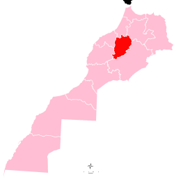 | |
| Cities | ||
Capital:Khenifra | ||
| Municipalities | ||
| Rural communes | ||