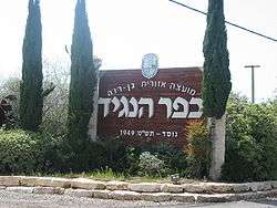
Kfar HaNagid
| Kfar HaNagid כְּפַר הַנָּגִיד | |
|---|---|
 | |
 Kfar HaNagid | |
| Coordinates: 31°53′13.56″N 34°44′56.75″E / 31.8871000°N 34.7490972°ECoordinates: 31°53′13.56″N 34°44′56.75″E / 31.8871000°N 34.7490972°E | |
| District | Central |
| Council | Gan Raveh |
| Affiliation | Moshavim Movement |
| Founded | 1949 |
| Founded by | Bulgarian-Jewish immigrants |
| Population (2017)[1] | 1,216 |
Kfar HaNagid (Hebrew: כְּפַר הַנָּגִיד, lit. Village of the Prince), is a moshav in central Israel. Located in the coastal plain around 20 km south of Tel Aviv and north of Yavne, it falls under the jurisdiction of Gan Raveh Regional Council. In 2017 it had a population of 1,216.[1]
History
The moshav was established in 1949 by immigrants from Bulgaria, and it was named after Samuel HaNagid.[2] According to Benny Morris, the moshav is founded near the land of the depopulated Palestinian village of al-Qubayba,[3] however, Walid Khalidi writes that it is only near the al-Qubayba site and that Kfar HaNagid is located on the land which belonged to Yibna.[4]
References
- 1 2 "List of localities, in Alphabetical order" (PDF). Israel Central Bureau of Statistics. Retrieved August 26, 2018.
- ↑ Mapa's concise gazetteer of Israel (in Hebrew). Yuval Elʻazari (ed.). Tel-Aviv: Mapa Publishing. 2005. p. 284. ISBN 965-7184-34-7.
- ↑ Morris, Benny (2004). Birth of the Palestinian Refugee Problem Revisited. Cambridge University Press. p. xxi, settlement #85, ISBN 0-521-00967-7
- ↑ Khalidi, Walid (1992). All That Remains:The Palestinian Villages Occupied and Depopulated by Israel in 1948. Washington D.C.: Institute for Palestine Studies. pp. 408, 423. ISBN 0-88728-224-5.
This article is issued from
Wikipedia.
The text is licensed under Creative Commons - Attribution - Sharealike.
Additional terms may apply for the media files.