Kettle River (Columbia River tributary)
| Kettle River | |
 | |
| Countries | United States, Canada |
|---|---|
| State | Washington |
| Province | British Columbia |
| Tributaries | |
| - left | Granby River |
| - right | West Kettle River, Rock Creek |
| City | Grand Forks, BC, Kettle Falls, WA |
| Source | Holmes Lake |
| - coordinates | 50°06′55″N 118°18′43″W / 50.11528°N 118.31194°W |
| Mouth | Columbia River |
| - location | Franklin D. Roosevelt Lake, Washington (state) |
| - elevation | 1,500 ft (457 m) [1] |
| - coordinates | 48°40′22″N 118°6′50″W / 48.67278°N 118.11389°WCoordinates: 48°40′22″N 118°6′50″W / 48.67278°N 118.11389°W [2] |
| Length | 175 mi (282 km) [3] |
| Basin | 4,200 sq mi (10,878 km2) [4] |
| Discharge | for Laurier, WA |
| - average | 2,906 cu ft/s (82 m3/s) |
| - max | 35,000 cu ft/s (991 m3/s) |
| - min | 70 cu ft/s (2 m3/s) |
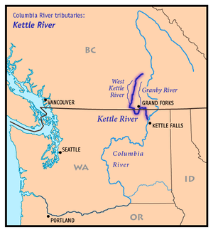 Map of the Kettle River and its two main tributaries | |
The Kettle River is a 281-kilometre (175 mi) tributary of the Columbia River in southeastern British Columbia in Canada and northeastern Washington in the United States. Its drainage basin is 10,877 square kilometres (4,200 sq mi) large, of which 8,228 square kilometres (3,177 sq mi) are in Canada and 2,649 square kilometres (1,023 sq mi) in the United States.[4] The indigenous name of the river in the Okanagan language is nxʷyaʔłpítkʷ (Ne-hoi-al-pit-kwu.[2])
Course
From its source at the outlet of Holmes Lake[5] in the Monashee Mountains of British Columbia, the Kettle River flows south to Midway, British Columbia. Along the way it is joined by many tributaries, most notably the West Kettle River. Below Midway, the river loops south, crossing the Canada–US border into the United States, through Ferry County, Washington, before flowing north back into Canada, passing by Grand Forks, British Columbia, where the Granby River joins. After flowing east for about 10 miles (16 km), the river turns south again, just south of Christina Lake,[6] entering the United States again. It then flows south, forming part of the Ferry-Stevens County line, before joining the Columbia River near Kettle Falls, Washington. The Columbia River at this point is a large reservoir impounded behind Grand Coulee Dam, called Lake Roosevelt. The Kettle enters the lake at the Columbia's river mile 706.[4] The Kettle River is undammed, making it one of the extremely few rivers with constant flow in the Pacific Northwest.
Natural history
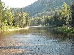
.jpg)
The Kettle River once supported salmon and other anadromous fish. The construction of Grand Coulee Dam, along with Chief Joseph Dam, blocked fish migration up the Columbia and its upper tributaries, including the Kettle River. In addition, Grand Coulee Dam's reservoir, Lake Roosevelt, flooded traditional fishery sites, including Kettle Falls near the mouth of the Kettle River.[4]
See also
| Wikimedia Commons has media related to Kettle River (Columbia River tributary). |
References
- ↑ Google Earth elevation for GNIS mouth coordinates; retrieved May 4, 2007.
- 1 2 USGS; U.S. Geological Survey Geographic Names Information System: Kettle River; retrieved May 4, 2007.
- ↑ Kettle River Archived 2008-07-16 at the Wayback Machine., The Columbia Gazetteer of North America
- 1 2 3 4 Upper Columbia Subbasin Overview, p. 29-8; Northwest Power and Conservation Council
- ↑ "Holmes Lake". BC Geographical Names.
- ↑ "Kettle River". BC Geographical Names.