Keslers Cross Lanes, West Virginia
| Kessler's Cross Lanes | |
|---|---|
| Unincorporated community | |
 Kessler's Cross Lanes Location within the state of West Virginia  Kessler's Cross Lanes Kessler's Cross Lanes (the US) | |
| Coordinates: 38°14′07″N 80°56′08″W / 38.23528°N 80.93556°WCoordinates: 38°14′07″N 80°56′08″W / 38.23528°N 80.93556°W | |
| Country | United States |
| State | West Virginia |
| County | Nicholas |
| Time zone | UTC-5 (Eastern (EST)) |
| • Summer (DST) | UTC-4 (EDT) |
| GNIS feature ID | 1541166[1] |
Kessler's Cross Lanes (sometimes misspelled as Kesler's Cross Lanes on maps) is an unincorporated community along Route 129 in Nicholas County, West Virginia, United States. Just south of Kessler's Cross Lanes is Carnifex Ferry Battlefield State Park, which is a park of historical interest; a Civil War battle was fought at the site in 1863.
Located nearby is the Capt. John Halstead Farm, listed on the National Register of Historic Places in 1998.[2]
Name
The community was named after Frederick Kessler, an early settler.[3]
See also
References
- ↑ U.S. Geological Survey Geographic Names Information System: Keslers Cross Lanes, West Virginia
- ↑ National Park Service (2010-07-09). "National Register Information System". National Register of Historic Places. National Park Service.
- ↑ Kenny, Hamill (1945). West Virginia Place Names: Their Origin and Meaning, Including the Nomenclature of the Streams and Mountains. Piedmont, WV: The Place Name Press. p. 348.
Municipalities and communities of Nicholas County, West Virginia, United States | ||
|---|---|---|
| City | 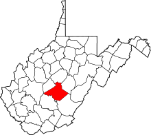 | |
| CDPs | ||
| Unincorporated communities |
| |
| Ghost towns | ||
| Footnotes | ‡This populated place also has portions in an adjacent county or counties | |
This article is issued from
Wikipedia.
The text is licensed under Creative Commons - Attribution - Sharealike.
Additional terms may apply for the media files.