Coe, West Virginia
| Coe, West Virginia | |
|---|---|
| Unincorporated community | |
 Coe, West Virginia  Coe, West Virginia | |
| Coordinates: 38°19′33″N 80°33′16″W / 38.32583°N 80.55444°WCoordinates: 38°19′33″N 80°33′16″W / 38.32583°N 80.55444°W | |
| Country | United States |
| State | West Virginia |
| County | Nicholas |
| Elevation | 2,749 ft (838 m) |
| Time zone | UTC-5 (Eastern (EST)) |
| • Summer (DST) | UTC-4 (EDT) |
| Area code(s) | 304 & 681 |
| GNIS feature ID | 1550752[1] |
Coe is an unincorporated community in Nicholas County, West Virginia, United States. Coe is located on County Route 7/6 5.4 miles (8.7 km) east of Craigsville.[2]
The community was named after George T. Coe, the original owner of the town site.[3] The Laurel Run Rockshelter was listed on the National Register of Historic Places in 1993.[4]
References
- ↑ "Coe". Geographic Names Information System. United States Geological Survey.
- ↑ Nicholas County, West Virginia General Highway Map (PDF) (Map). West Virginia Department of Transportation. 2011. p. 3. Retrieved June 30, 2011.
- ↑ Kenny, Hamill (1945). West Virginia Place Names: Their Origin and Meaning, Including the Nomenclature of the Streams and Mountains. Piedmont, WV: The Place Name Press. p. 181.
- ↑ National Park Service (2010-07-09). "National Register Information System". National Register of Historic Places. National Park Service.
Municipalities and communities of Nicholas County, West Virginia, United States | ||
|---|---|---|
| City | 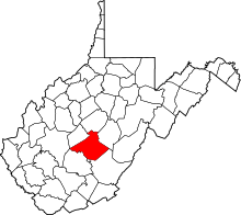 | |
| CDPs | ||
| Unincorporated communities |
| |
| Ghost towns | ||
| Footnotes | ‡This populated place also has portions in an adjacent county or counties | |
This article is issued from
Wikipedia.
The text is licensed under Creative Commons - Attribution - Sharealike.
Additional terms may apply for the media files.