Kerkini
| Kerkini Κερκίνη | |
|---|---|
 Kerkini Location within the regional unit  | |
| Coordinates: 41°13′N 23°05′E / 41.217°N 23.083°ECoordinates: 41°13′N 23°05′E / 41.217°N 23.083°E | |
| Country | Greece |
| Administrative region | Central Macedonia |
| Regional unit | Serres |
| Municipality | Sintiki |
| • Municipal unit | 353.6 km2 (136.5 sq mi) |
| Population (2011)[1] | |
| • Municipal unit | 6,695 |
| • Municipal unit density | 19/km2 (49/sq mi) |
| Community[1] | |
| • Population | 1,371 (2011) |
| Time zone | UTC+2 (EET) |
| • Summer (DST) | UTC+3 (EEST) |
| Vehicle registration | ΕΡ |
| Website | https://www.sintiki.gov.gr/ |
Kerkini (Greek: Κερκίνη) is a village and a former municipality in the Serres regional unit, Greece. Since the 2011 local government reform it is part of the municipality Sintiki, of which it is a municipal unit.[2] It is named after ancient Kerkinitis lake (see map of Macedon). The municipal unit has an area of 353.634 km2.[3] Population of the municipal unit 6,695 (2011). The seat was in Rodopoli.
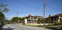
Hotel Oikoperiigitis in Kerkini
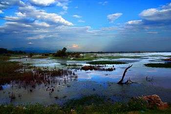
Lake Kerkini by Vlahos Vaggelis

Lake Kerkini by Vlahos Vaggelis
References
- 1 2 "Απογραφή Πληθυσμού - Κατοικιών 2011. ΜΟΝΙΜΟΣ Πληθυσμός" (in Greek). Hellenic Statistical Authority.
- ↑ Kallikratis law Greece Ministry of Interior (in Greek)
- ↑ "Population & housing census 2001 (incl. area and average elevation)" (PDF) (in Greek). National Statistical Service of Greece. Archived from the original (PDF) on 2015-09-21.
This article is issued from
Wikipedia.
The text is licensed under Creative Commons - Attribution - Sharealike.
Additional terms may apply for the media files.