Kerama Islands
| Native name: 慶良間諸島 | |
|---|---|
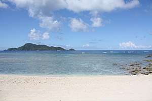 Sea view of Kerama Islands with surrounding coral reefs | |
 | |
| Geography | |
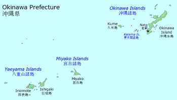
| Location | Pacific Ocean |
| Archipelago | Okinawa Islands |
| Administration | |
|
Japan | |
| Prefecture | Okinawa Prefecture |
| Official name | Keramashoto Coral Reef |
| Designated | 8 November 2005 |
| Reference no. | 1546[1] |
The Kerama Islands (慶良間諸島 Kerama-shotō, Okinawan: キラマ Kirama) are a group of 22 islands located 32 kilometres (20 mi) southwest of Okinawa Island in Japan. Historically, the Kerama Island group was a part of the Ryukyu Kingdom. For some 600 years, the islanders were employed as skillful navigators for the Kingdom’s trading vessels between Okinawa and China.[2]
Four of the islands are inhabited: Tokashiki Island, Zamami Island, Aka Island, and Geruma Island.[3] The islands are within Shimajiri District.[4] The Kerama-shotō coral reef is a Ramsar Site.[5]
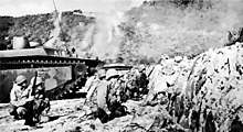
During World War II and preliminary to the Battle of Okinawa, soldiers of the 77th Infantry Division landed in the Kerama Islands on March 26, 1945. Further landings followed, and the Kerama group was secured over the next five days. Kerama was used as a staging area for the assault on Okinawa. During the battle the first civilian mass suicides that later marked the Battle of Okinawa took place.
The first US Navy ship to anchor in the harbor was USS Makin Island, a small "jeep" carrier.
It was the site of a true story about romance between two dogs who lived on neighboring islands that was made into the 1988 Japanese film I Want to See Marilyn (Marilyn ni Aitai).[6] It is now a popular beach and diving destination for visitors to Okinawa.
Transportation
The Kerama Islands are served by the Kerama Airport, located on Fukaji Island.[7] Regular ferries are also available from Naha to the three largest islands, Aka, Zamami, and Tokashiki. Ferries between the islands are also available, as are boat tours.
References
- ↑ "Keramashoto Coral Reef". Ramsar Sites Information Service. Retrieved 25 April 2018.
- ↑ "Kerama islands". Kerama islands. Retrieved 2016-06-10.
- ↑ Kerama Islands. Open Coast Travel.
- ↑ Special Feature #1 : Seas of Okinawa -The Kerama Islands- Archived 2011-05-17 at the Wayback Machine., Okinawa Prefecture
- ↑ "Ramsar Sites in Japan - Kerama-shoto Coral Reef" (PDF). Ministry of the Environment. Retrieved 24 March 2011.
- ↑ Marilyn Ni Aitai on IMDb
- ↑ Map showing islands of Zamami Village Archived 2011-05-26 at the Wayback Machine.
External links
| Wikimedia Commons has media related to Kerama Islands. |