Kent, Texas
Well known Dallas businessman, W. C. “Chuck” Adams, owner of Sew-Vac, Inc. and International Mail Order Co., died in Kent, Texas, when his private plane, a Cessna 172H Skyhawk, N2757L, crashed seven miles north of Kent proper, within the Apache Mountain range. Adams was flying with his two older sons, Chuck Jr. and Charles Rodney, from Pecos to Van Horn that morning. Both sons survived the crash in the early morning hours of November 18, 1978. A man driving by found the crash about an hour later, approximately around 8am. Adams was found expired, with Chuck Jr, co-pilot, still inside the plane with him, with near-fatal injuries. The younger son, Rodney, was found thrown outside the plane, with only minor injuries. Chuck Jr., due to the magnitude of his injuries from the crash, passed away on February 5, 1987, and is interred in the cemetery in Dawson, Texas, with his maternal grandparents.
William Charles Adams, Sr., originally from Frost, Texas, is interred in Dallas, Texas, in the Sparkman-Hillcrest Memorial Gardens. However, a small memorial has been placed in Kent, in his memory as well.
Ironically, CR 2424, heading north from Interstate 10 from Kent, is also given the name Cesna Ave. (correct spelling). The other road, Hwy 118, also ironically, shares the numerical day of the crash, 11-18.
| Kent, Texas | |
|---|---|
| Unincorporated community | |
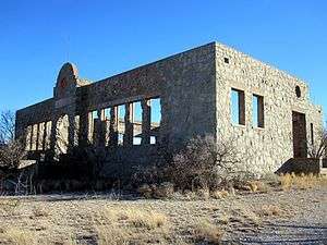 Ruins of Kent Public School | |
| Nickname(s): Kent Ghost Town | |
 Kent Location of Kent in West Texas  Kent Kent (the US) | |
| Coordinates: 31°04′09″N 104°13′02″W / 31.06917°N 104.21722°WCoordinates: 31°04′09″N 104°13′02″W / 31.06917°N 104.21722°W | |
| Country | United States |
| State | Texas |
| County | Culberson |
| Elevation[1] | 4,206 ft (1,282 m) |
| Population (2000[2]) | |
| • Total | 60 |
| Time zone | UTC-6 (Central (CST)) |
| • Summer (DST) | UTC-5 (CDT) |
| ZIP code | 79855 |
| Area code(s) | 915 |
Kent is an unincorporated community in Culberson County, Texas, United States. It lies just north of Interstate 10 at Exit 176, ten miles west of the beginning of Interstate 20 and four miles west of the eastern Culberson County boundary. It is sandwiched between the railroad, immediately to its north, and the interstate. As of 2005, its composition was a population estimated at 60 residents and three small businesses – a general store, a service station and a post office, as well as ruins of a public school and other businesses which flourished until the 1960s. As of 2014, only the general store remained in operation; the nearest service station is in Plateau, 18 miles west along the Interstate. It therefore has had no medical, pharmaceutical, public educational, legal, police, fire or other governmental services beyond the post office within its boundaries, the nearest source of these being in Van Horn, 37 miles west. There are also no motels, hotels or trailer/RV parks, restaurants or other tourist services. The surrounding county area which it serves contains semi-desert land supporting large cattle ranches.
Climate
According to the Köppen Climate Classification system, Kent has a semi-arid climate, abbreviated "BSk" on climate maps.[3]
| Climate data for Kent, Texas. (1988-2017) | |||||||||||||
|---|---|---|---|---|---|---|---|---|---|---|---|---|---|
| Month | Jan | Feb | Mar | Apr | May | Jun | Jul | Aug | Sep | Oct | Nov | Dec | Year |
| Record high °F (°C) | 81 (27) |
83 (28) |
89 (32) |
96 (36) |
101 (38) |
113 (45) |
109 (43) |
103 (39) |
102 (39) |
98 (37) |
92 (33) |
83 (28) |
113 (45) |
| Average high °F (°C) | 57.6 (14.2) |
61.1 (16.2) |
68.2 (20.1) |
76.9 (24.9) |
84.7 (29.3) |
91.4 (33) |
88.8 (31.6) |
87.9 (31.1) |
82.6 (28.1) |
76.0 (24.4) |
65.5 (18.6) |
57.5 (14.2) |
74.8 (23.8) |
| Average low °F (°C) | 31.8 (−0.1) |
35.0 (1.7) |
39.9 (4.4) |
47.5 (8.6) |
56.4 (13.6) |
63.6 (17.6) |
64.5 (18.1) |
63.5 (17.5) |
57.6 (14.2) |
49.5 (9.7) |
38.4 (3.6) |
31.8 (−0.1) |
48.3 (9.1) |
| Record low °F (°C) | 6 (−14) |
0 (−18) |
11 (−12) |
23 (−5) |
33 (1) |
47 (8) |
52 (11) |
53 (12) |
34 (1) |
20 (−7) |
10 (−12) |
0 (−18) |
0 (−18) |
| Average precipitation inches (mm) | 0.59 (15) |
0.78 (19.8) |
0.47 (11.9) |
0.55 (14) |
1.00 (25.4) |
1.24 (31.5) |
2.97 (75.4) |
2.36 (59.9) |
1.98 (50.3) |
1.03 (26.2) |
0.49 (12.4) |
0.60 (15.2) |
14.05 (356.9) |
| Average snowfall inches (cm) | 0.7 (1.8) |
0.0 (0) |
0.0 (0) |
0.0 (0) |
0.0 (0) |
0.0 (0) |
0.0 (0) |
0.0 (0) |
0.0 (0) |
0.0 (0) |
0.3 (0.8) |
0.7 (1.8) |
1.7 (4.3) |
| Source: The Western Regional Climate Center[4] | |||||||||||||
See also
References
- ↑ "Kent". Geographic Names Information System. United States Geological Survey.
- ↑ Kent at TSHA
- ↑ Climate Summary for Kent, Texas
- ↑ "Seasonal Temperature and Precipitation Information". Western Regional Climate Center. Retrieved December 16, 2014.
External links
- U.S. Geological Survey Geographic Names Information System: Kent, Texas
- Photos of West Texas and Eastern New Mexico
Municipalities and communities of Culberson County, Texas, United States | ||
|---|---|---|
| Town | 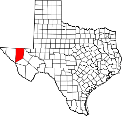 | |
| Unincorporated communities | ||
| Ghost town | ||