Kempville, Tennessee
| Kempville, Tennessee | |
|---|---|
| Unincorporated community | |
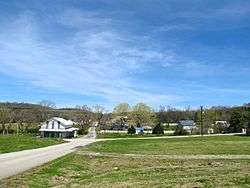 Houses in Kempville | |
 Kempville, Tennessee  Kempville, Tennessee | |
| Coordinates: 36°20′48″N 85°51′47″W / 36.34667°N 85.86306°WCoordinates: 36°20′48″N 85°51′47″W / 36.34667°N 85.86306°W | |
| Country | United States |
| State | Tennessee |
| County | Smith |
| Elevation | 623 ft (190 m) |
| Time zone | UTC-6 (Central (CST)) |
| • Summer (DST) | UTC-5 (CDT) |
| ZIP codes | 37030, 37145 |
| Area code(s) | 615 |
| GNIS feature ID | 1290057[1] |
Kempville is an unincorporated community in Smith County, Tennessee, United States.[1] It is located along State Route 85 in a hilly area northeast of Carthage. Kempville Branch, a tributary of Defeated Creek, flows through the community.
Kempville was probably named for a family of early settlers in the area.[2]
References
- 1 2 "Kempville, Tennessee". Geographic Names Information System. United States Geological Survey.
- ↑ Larry Miller, Tennessee Place Names (Indiana University Press, 2001), p. 112.
External links

Municipalities and communities of Smith County, Tennessee, United States | ||
|---|---|---|
| Towns | ||
| Unincorporated communities | ||
This article is issued from
Wikipedia.
The text is licensed under Creative Commons - Attribution - Sharealike.
Additional terms may apply for the media files.