Kemalpaşa, Artvin
| Kemalpaşa | |
|---|---|
| Town | |
 | |
 Kemalpaşa Location in Turkey | |
| Coordinates: 41°29′N 41°31′E / 41.483°N 41.517°ECoordinates: 41°29′N 41°31′E / 41.483°N 41.517°E | |
| Country |
|
| Province | Artvin Province |
| District | Hopa |
| Elevation | 10 m (33 ft) |
| Population (2013) | |
| • Total | 5,216 |
| Time zone | UTC+2 (EET) |
| • Summer (DST) | UTC+3 (EEST) |
| Postal code | 08610 |
| Area code(s) | 466 |
| Licence plate | 08 |
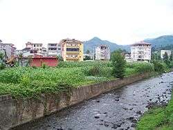
Kemalpaşa (former Makriyali; Laz and Georgian: მაკრიალი/Makriali or ნოღედი/Noghedi) is a coastal belde (town) in Hopa district of Artvin Province, Turkey. At 41°29′N 41°31′E / 41.483°N 41.517°E it is 15 kilometres (9.3 mi) east of Hopa and 5 kilometres (3.1 mi) west of the Sarp border check point to Georgia. The population of the town was 5216[1] as of 2013.
Until 1547 it was a part of the Principality of Guria of the Kingdom of Imereti. In June 1367 here in Makriali Church the royal wedding took place between the king Bagrat V of Georgia and Anna of Trebizond. In 1547 it was annexed to Ottoman Empire. From 1915 to 1917 — occupied by the Russian Empire during the First World War. From 1918 to 1921 Kemalpaşa became a part of the Democratic Republic of Georgia. After the occupation of the Georgian Democratic Republic by the Soviet Red Army, the village was ceded to Turkey in 1922. In 1987 it was declared township.[2]
See also
References
- ↑ "Turkstat". Turkish Statistical Institute. Archived from the original on 23 January 2015. Retrieved 23 January 2015.
- ↑ Mayor’s page (in Turkish)