Keila Parish
| Keila Parish Keila vald | |||
|---|---|---|---|
| Former municipality of Estonia | |||
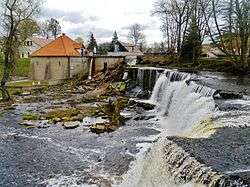 Keila-Joa waterfall | |||
| |||
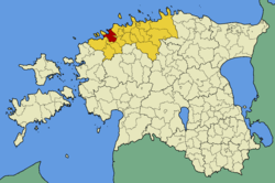 Keila Parish within Harju County. | |||
| Country |
| ||
| County |
| ||
| Administrative centre | Keila | ||
| Government | |||
| • Mayor | Kadri Tillemann | ||
| Area | |||
| • Total | 178.97 km2 (69.10 sq mi) | ||
| Population (01.01.2004) | |||
| • Total | 3,995 | ||
| • Density | 22/km2 (58/sq mi) | ||
| Website | www.keilavald.ee | ||


Keila Parish (Estonian: Keila vald) was a rural municipality in north-western Estonia. It was a part of Harju County. The municipality had a population of 3,995 (as of 1 January 2004)[1] and covered an area of 178.97 km². The population density was 22.3 inhabitants per km².
Local administration of the municipality was located in the town of Keila, although the town itself constitutes separate urban municipality and was not part of Keila Parish. In Keila Parish there were 3 small boroughs (Estonian: alevikud): Karjaküla, Klooga, Keila-Joa and 19 villages (Estonian: külad): Illurma, Käesalu, Keelva, Kersalu, Kloogaranna, Kulna, Laoküla, Laulasmaa, Lehola, Lohusalu, Maeru, Meremõisa, Nahkjala, Niitvälja, Ohtu, Põllküla, Tõmmiku, Tuulna, Valkse.
Gallery
 Ohtu bog
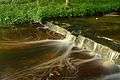 Treppoja
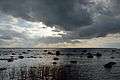 Lahepere bay and Pakri peninsula
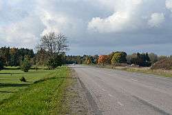 Tallinn–Paldiski road in Valkse
 Offering spring in Ohtu
 Kõltsu manor
References
- ↑ "Arengukava 2004-2014" (PDF) (in Estonian). Keila Vald http://www.keilavald.ee. Archived from the original (PDF) on 16 July 2011. Retrieved 11 December 2009. External link in
|publisher=(help)
External links
Coordinates: 59°21′05″N 24°35′56″E / 59.35139°N 24.59889°E