Keenagh
| Keenagh Caonach | |
|---|---|
| Town | |
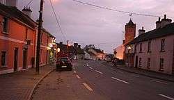 Main Street (R397) with clock tower | |
 Keenagh Location in Ireland | |
| Coordinates: 53°37′24″N 7°48′58″W / 53.623458°N 7.816086°WCoordinates: 53°37′24″N 7°48′58″W / 53.623458°N 7.816086°W | |
| Country | Ireland |
| Province | Leinster |
| County | County Longford |
| Population (2011) | |
| • Urban | 900 |
| Time zone | UTC+0 (WET) |
| • Summer (DST) | UTC-1 (IST (WEST)) |
| Irish Grid Reference | N125638 |

Rainbow near Keenagh.
Keenagh or Kenagh (Irish: Caonach, meaning "moss"[1]) is a village in County Longford, Ireland. It is situated on the R397 near the Royal Canal.
A small village with two churches, (Catholic and Church of Ireland), a couple of shops and three pubs, it lies 14 km (8.7 mi) south of Longford Town. There is also a GAA club in the village and a community centre.
Corlea Trackway is an Iron Age trackway near the village.
In the period 2000 to 2007 many new houses were built around Keenagh, due to the tax incentives available in the area and without direct consideration to demand - many are now vacant or incomplete constituting ghost estates.[2]
See also
- List of towns and villages in Ireland
- Keenagh, Templeport, a townland in the parish of Templeport, County Cavan
References
- ↑ A. D. Mills, 2003, A Dictionary of British Place-Names, Oxford University Press
- ↑ "Archived copy". Archived from the original on 2012-03-21. Retrieved 2011-09-09.
This article is issued from
Wikipedia.
The text is licensed under Creative Commons - Attribution - Sharealike.
Additional terms may apply for the media files.