Kedrinos Lofos
Kedrinos Lofos (Greek: Κέδρινος Λόφος, Cedar Hill), also known as Seich Sou (Σέιχ Σου, from Turkish: Şeyh Su, meaning the Sheikh's Water), is a hilltop forest just to the north and northeast of the city of Thessaloniki, Greece that rises to the west of Mount Chortiatis. The forest has an expanse of 2,979 hectares (7,361 acres) and reaches an elevation of 563 meters (1,847 feet).[1]
Flora and Fauna
The forest hosts 277 plant species, which pine trees (Pinus brutia, Pinus pinea and Pinus halepensis) dominate. There are also scattered cypress (Cupressus sempervirens), plane trees (Platanus orientalis), and many species of populus.[2]
Kedrinos Lofos is also home to a rich variety of fauna. Hares, foxes, martens, squirrels, weasels, and hedgehogs are among the mammals that make their home there. Around 80 types of birds frequent the forest, chief among them the short-toed snake eagle, the common cuckoo, nightingales, the rock partridge, owls, and the song thrush. Salamanders, frogs, turtles, grass snakes, and lizards are the most common amphibians and reptiles.[3]
Etymology
The southwestern portion of the forest was originally called Chilia Dentra (Greek: Χίλια Δέντρα) or Thousand Trees as it was one of the parts that was spared deforestation during the Ottoman period. It is during this Ottoman period that the area receives the name شهیح سو, or Şeyh Su in the modern Turkish alphabet, meaning the Sheikh's Water. The name is derived from a spring located near a mausoleum within the forest. The name has since entered the Greek language as Seich Sou (Σέιχ Σου). It received its current name of Kedrinos Lofos (Greek: Κεδρηνός Λόφος) or Cedar Hill in 1987 when a local poet, George Vafopoulos, suggested it in Thessaloniki's city council.[4] The name Kedrinos is a play on a Byzantine-era historian, George Kedrenos, who wrote extensively on the forest and on the word 'cedar'.
History
Originally, the area was an oak (primarily Quercus pubescens) forest which was the source of all the rivers that ran through the city of Thessaloniki that ultimately emptied into the Thermaic Gulf.[4] During the Ottoman era, logging, grazing, and farming contributed to the deforestation of the area.[3]
In 1921, a decision was made to reforest the area by the Hellenic Ministry of Agriculture. This project was undertaken by the Forestry School of the Aristotle University of Thessaloniki which planted nearly 5 million trees between 1929 and 1989.[3]
In 1982 a small fire broke out in the forest.[4]
On July 7, 1997, a large fire broke out and burned 55% of the forest down over a period of 60 hours.[2] Two large reforestation projects took place in 1998 and 2000, however most of the reforestation has been natural. As of 2010, 36.4% still remains clear of trees.
Sites
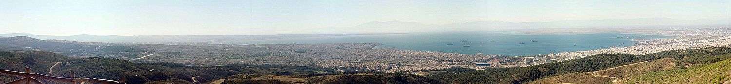
The forest is home to Thessaloniki's main zoo, its natural history museum, two amphitheatrical open-air theaters overlooking the city (Theatro Dasous or Forest Theater and Theatro Gaias or Earth Theater), hiking and biking trails, as well as two lookout points that overlook the city.
Issues
The pine trees have suffered the infestation of the pine processionary which has led to defoliation and to calls for a greater variety in the forest's flora.[4]
Thessaloniki's heavily congested ring road abuts the southern side of the forest.
References
- ↑ Stefanos Ioakeimidis; Dimitris Kaimaris. "Observation of the Changes and the Degradation of the Forests after the Fire with the Use of Remote Sensing and GIS: Study of the Suburban Forest of Seich Sou, Thessaloniki, Greece" (PDF). The Global Network on Environmental Science and Technology. Retrieved 2 September 2018.
- 1 2 "Mapping the Peri-Urban Forest of Thessaloniki after the Big Fire of 1997 Using Ikonos Imagery" (PDF). European Association of Remote Sensing Laboratories. Aristotle University of Thessaloniki, Department of Forestry, Laboratory of Forest Management and Remote Sensing Thessaloniki.
- 1 2 3 "Το Σειχ Σου". Όλυμπος. 148: 35. Winter 2008.
- 1 2 3 4 "Προστατευτικός ρόλος του δάσους του Σέιχ Σου. Ανασύνταξη και ανασχεδιασμός υποδομών. Σύνδεση με την πόλη" (PDF). Aristotle University of Thessaloniki. Retrieved 2 September 2018.
Coordinates: 40°38′20″N 22°59′31″E / 40.6387664°N 22.9920734°E