Kaymaz
| Kaymaz | |
|---|---|
| Town | |
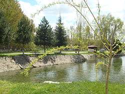 A scene from the town | |
 Kaymaz Location in Turkey | |
| Coordinates: 39°31′N 31°11′E / 39.517°N 31.183°ECoordinates: 39°31′N 31°11′E / 39.517°N 31.183°E | |
| Country |
|
| Province | Eskişehir Province |
| District | Sivrihisar |
| Elevation | 970 m (3,180 ft) |
| Population (2012) | |
| • Total | 1,254 |
| Time zone | UTC+2 (EET) |
| • Summer (DST) | UTC+3 (EEST) |
| Postal code | 26640 |
| Area code(s) | 0222 |
| Licence plate | 26 |
Kaymaz is a town in the Sivrihisar district of Eskişehir Province, Turkey. It is situated at 39°31′N 31°11′E / 39.517°N 31.183°E, on Turkish state highway ![]()
In 1963, it was declared a seat of township. There are various ruins around the town. In contrast to general scenery of Central Anatolia, Kaymaz is a watery town thanks to Kaymaz Dam to the north east of the town. It is also known as Yeşilkaymaz ("Green Kaymaz"). Beans and cherries are the main products of the town.[2]
It has an annual Festival of Kuru Fasulye.[3]