Kasol
| Kasol | |
|---|---|
| Hill Station | |
 Kasol Mountain View | |
| Nickname(s): Mini Israel of India | |
 Kasol Location in Himachal Pradesh, India  Kasol Kasol (India) | |
| Coordinates: 32°00′35″N 77°18′55″E / 32.00972°N 77.31528°E | |
| Country |
|
| State | Himachal Pradesh |
| District | Kullu |
| Area | |
| • Total | 0.36 km2 (0.14 sq mi) |
| Elevation | 1,580 m (5,180 ft) |
| Languages | |
| • Official | Hindi English |
| Time zone | UTC+5:30 (IST) |
| Telephone code | 01907 |
| Vehicle registration | HP- HP- |
| Nearest city | Kullu |
| Literacy | Low% |
| Climate | cool (Köppen) |
Kasol is a hamlet in the district Kullu, Himachal Pradesh, northern India.[1][2] It is situated in Parvati Valley, on the banks of the Parvati River, on the way between Bhuntar and Manikaran. It is located 31.2 km from Bhuntar[3] and 5 km from Manikaran. Kasol is the Himalayan hotspot for backpackers.[4] and acts as a base for nearby treks to Malana and Kheerganga. It is called Mini Israel of India due to strong Jewish history and heritage found here.[5]
Climate
Kasol has good weather throughout the year and receives fair amount of snowfall from late December to February. Köppen-Geiger climate classification system classifies its climate as humid subtropical (Cfa).[6]
| Climate data for Kasol, Himachal Pradesh | |||||||||||||
|---|---|---|---|---|---|---|---|---|---|---|---|---|---|
| Month | Jan | Feb | Mar | Apr | May | Jun | Jul | Aug | Sep | Oct | Nov | Dec | Year |
| Average high °C (°F) | 11.6 (52.9) |
14.2 (57.6) |
18.8 (65.8) |
24 (75) |
28.2 (82.8) |
29.3 (84.7) |
25.9 (78.6) |
25 (77) |
24.6 (76.3) |
22.2 (72) |
18.3 (64.9) |
14.2 (57.6) |
21.4 (70.4) |
| Daily mean °C (°F) | 7.4 (45.3) |
9.7 (49.5) |
14 (57) |
18.7 (65.7) |
22.9 (73.2) |
24.3 (75.7) |
22.3 (72.1) |
21.7 (71.1) |
20.6 (69.1) |
17.5 (63.5) |
13.3 (55.9) |
9.7 (49.5) |
16.8 (62.3) |
| Average low °C (°F) | 3.2 (37.8) |
5.2 (41.4) |
9.2 (48.6) |
13.4 (56.1) |
17.6 (63.7) |
19.4 (66.9) |
18.8 (65.8) |
18.4 (65.1) |
16.7 (62.1) |
12.8 (55) |
8.4 (47.1) |
5.3 (41.5) |
12.4 (54.3) |
| Average precipitation mm (inches) | 111 (4.37) |
108 (4.25) |
155 (6.1) |
103 (4.06) |
100 (3.94) |
93 (3.66) |
324 (12.76) |
276 (10.87) |
160 (6.3) |
70 (2.76) |
27 (1.06) |
55 (2.17) |
1,582 (62.3) |
| Source: Climate-Data.org (altitude: 1582m)[6] | |||||||||||||
Transport
There are different transport options available to reach Kasol. To reach Kasol one must first reach Bhuntar from where you have the option to use the Bus service which is available hourly and is available only between 8AM to 6PM. However, the local Taxi Service is available all the times. Bhuntar also has the nearest Kullu–Manali Airport (IATA: KUU, ICAO: VIBR). Kasol being one of the most famous tourist places in the region has frequent local bus service running from Manali.[7] There is no direct flight or rail connectivity to Kasol.[8]
Festivals
Kasol Music Festival is one of the famous music festival in Kasol which happens on every new year eve. The concept of this festival is to take you back to the Himalayan vibes. People from around the globe gather for the love of music, art and nature.
Gallery
 Kasol Valley Forest Camping
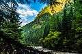 Kasol River Side Village
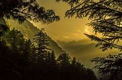
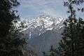 Himalayan Region View from Kasol
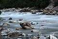 Parvati River
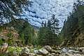 The Majestically beautiful Parvati Valley, Himachal Pradesh
.jpg) Himalayan Bulbul spotted
Himalayan Bulbul spotted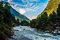 Parvati River in between Kasol mountains
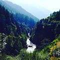 The famous Kheerganga Trek route
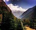 Parvati Valley amazing view
External links
| Wikimedia Commons has media related to Kasol. |
References
- ↑ "Say 'High' - Kasol". Retrieved 7 May 2014.
- ↑ NREGA report
- ↑ "Google Maps". Google Maps. Retrieved 2017-06-07.
- ↑ "www.kasol.net - The website of Kasol". Retrieved 2017-12-09.
- ↑ Why Israeli tourists in Kasol, called mini-Israel, are euphoric about Modi's visit
- 1 2 "Kasol - Climate graph, Temperature graph, Climate table". Climate-Data.org. Retrieved 2016-03-10.
- ↑ "My first trip to India - Kasol & Tosh". Retrieved 2017-05-25.
- ↑ "How to Reach KASOL?". Retrieved 2017-12-09.