Kashgar–Hotan railway
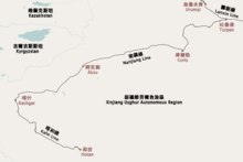
Map of the Kashgar–Hotan (Kahe) railway
The Kashgar–Hotan railway or Kahe railway (Chinese: 喀什至和田铁路; pinyin: Kāshí zhì Hétián Tiělù, abbreviated Chinese: 喀和铁路; pinyin: Kā-Hé Tiělù) is a single-track, non-electrified, railway in Xinjiang, China between Kashgar and Hotan. The railway is 488.27 km (303.40 mi) in length and runs along the southern edge of the Taklamakan Desert, connecting all major cities and towns of the southwestern Tarim Basin, including Shule, Akto, Yengisar, Yarkant (Shache), Poskam (Zepu), Karghilik (Yecheng), Pishan (Guma) and Karakax (Moyu).[1] The line extends the Southern Xinjiang Railway east from Kashgar.[1] Construction began in December 2008.[1] The line opened to freight traffic on December 30, 2010.[1] Passenger service began on June 28, 2011.[2]
Station list
| Station | Chinese | Distance (km²) | Location | |
|---|---|---|---|---|
| Kashi Southern Xinjiang Railway | 喀什 | 0 | Kashi | Kashi Prefecture |
| Shule | 疏勒 | 14 | Shule County | Kashi Prefecture |
| Akto | 阿克陶 | 38 | Akto County | Kizilsu Prefecture |
| Yengisar | 英吉沙 | 66 | Yengisar County | Kashi Prefecture |
| Kezile | 克孜勒 | Yengisar County | Kashi Prefecture | |
| Mayake | 马牙克 | Yengisar County | Kashi Prefecture | |
| Tuoluolake | 托洛拉克 | Shache County | Kashi Prefecture | |
| Shache | 莎车 | 187 | Shache County | Kashi Prefecture |
| Zepu | 泽普 | Zepu County | Kashi Prefecture | |
| Yecheng | 叶城 | 246 | Yecheng County | Kashi Prefecture |
| Kuoshan | 阔什 | Pishan County | Hotan Prefecture | |
| Pishan | 皮山 | 327 | Pishan County | Hotan Prefecture |
| Zanggui | 藏桂 | Pishan County | Hotan Prefecture | |
| 224 Tuan | 二二四团 | Moyu County | Hotan Prefecture | |
| Moyu | 墨玉 | 468 | Moyu County | Hotan Prefecture |
| Hotan | 和田 | 485 | Hotan | Hotan Prefecture |
See also
References
- 1 2 3 4 新疆喀什至和田铁路30日全线通车 货运列车开行 (in Chinese). December 30, 2010. Archived from the original on October 8, 2011.
- ↑ 新疆喀和铁路客运通车 (in Chinese). Central People's Government of the People's Republic of China. June 28, 2011.
This article is issued from
Wikipedia.
The text is licensed under Creative Commons - Attribution - Sharealike.
Additional terms may apply for the media files.