Karmala Taluka
| Karmala Taluka | |
|---|---|
| Taluka | |
| Country | India |
| State | Maharashtra |
| District | Solapur District |
| Headquarters | Karmala |
| Area[1] | |
| • Total | 1,609.7 km2 (621.5 sq mi) |
| Population (2001 census)[1] | |
| • Total | 233,316 |
| • Density | 140/km2 (380/sq mi) |
| • Sex ratio | 925 |
| ISO 3166 code | IN-MH |
| Villages | 118[1] |
| Revenue circles | 6 |
| Average rainfall | 506 mm |
Karmala Taluka is one of the 11 talukas of Solapur district in the Indian state of Maharashtra.
As of 2001, the taluka population was 233,316.[1] The 2011 census of India recorded a figure of 231,290, spread over 184,380 hectares (455,600 acres).[2]
See also
References
- 1 2 3 4 "Karmala Taluka facts" (PDF). Collectorate of Solapur. Archived (PDF) from the original on 21 July 2011.
- ↑ "Census of India 2011: Maharashtra Series 28, Part XII District Census Handbook Solapur Primary Census Abstract" (PDF). Directorate of Census Operations Maharashtra. p. 108. Retrieved 2018-01-24.
External links
Solapur district topics | ||
|---|---|---|
| History | 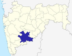 | |
| Rivers | ||
| Dams | ||
| Tehsils | ||
| Cities and towns | ||
| Places to see | ||
| Education | ||
| Transport | ||
| Lok Sabha constituencies | ||
| Vidhan Sabha constituencies | ||
| Culture | ||
| Sports | ||
This article is issued from
Wikipedia.
The text is licensed under Creative Commons - Attribution - Sharealike.
Additional terms may apply for the media files.