Kanoko Dam
| Kanoko Dam | |
|---|---|
 | |
| Location | Hokkaidō, Japan. |
| Coordinates | 43°36′26″N 143°23′16″E / 43.60722°N 143.38778°ECoordinates: 43°36′26″N 143°23′16″E / 43.60722°N 143.38778°E |
| Construction began | 1972 |
| Opening date | 1983 |
| Dam and spillways | |
| Impounds | Tokoro River |
| Height | 55.5 m |
| Length | 222 m |
| Reservoir | |
| Total capacity | 39,800,000 m³ |
| Catchment area | 204 km² |
| Surface area | 124 hectares |
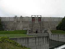
The Kanoko Dam (鹿ノ子ダム) is a concrete Gravity dam in Oketocho, Hokkaidō, Japan. The dam is situated upon the Tokoro River. The dam is a multipurpose dam with a flood control function, as well as to provide irrigation to Kitami City among other municipalities, for irrigation, and for river flow control.[1]
The artificial lake created by the construction of the dam is known as Oketo Lake.
The region surrounding the dam is largely used for agriculture. The dam was needed for flood control as well as to support the growing local populations and increased use of agricultural technology.
Dam Construction
In 1968 The Hokkaido Development Bureau as well as the Abashiri Construction Development Department were planning a comprehensive flood control and irrigation strategy.[2] In 1972, the project was implemented. Work began on road reconstructions and maintenance work of the surrounding area, along with compensation negotiations with the affected populations. In 1979, the project entered into the main construction phase which was completed in 1983.
| Wikimedia Commons has media related to Dams in Hokkaido. |
References
- ↑ "鹿ノ子ダム ─鹿ノ子ダムの目的". www.ab.hkd.mlit.go.jp (in Japanese). Retrieved 2017-03-18.
- ↑ "鹿ノ子ダム ─鹿ノ子ダムができるまで". www.ab.hkd.mlit.go.jp (in Japanese). Retrieved 2017-03-18.