Kanjikkuzhi
| Kanjikkuzhi | |
|---|---|
| town | |
 Muhamma panchayath Office | |
 Kanjikkuzhi Location in Kerala, India  Kanjikkuzhi Kanjikkuzhi (India) | |
| Coordinates: 9°45′0″N 76°36′0″E / 9.75000°N 76.60000°ECoordinates: 9°45′0″N 76°36′0″E / 9.75000°N 76.60000°E | |
| Country |
|
| State | Kerala |
| District | Kottayam |
| Government | |
| • Body | Nagar Palika |
| Population (2012) | |
| • Total | 14,076 |
| Languages | |
| • Official | Malayalam, English |
| Time zone | UTC+5:30 (IST) |
| Vehicle registration | KL |
| Lok Sabha constituency |
assembly_const = altitude = |
Kanjikkuzhi is a census town in Kottayam district in the Indian state of Kerala. It is a suburb of Kottayam City. It lies on the Kottayam - Kumily state highway (K.K road).
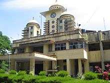
Kottayam collectorate near Kanjukuzhy
Demographics
According to the 2012 India census,[1] Kanjikkuzhi had a population of 14,076. Males constituted 49% of the population and females 51%. Kanjikkuzhi had an average literacy rate of 86%, higher than the national average of 59.5%: male literacy was 88% and female literacy was 84%. 10% of the population were under 6 years of age.
References
- ↑ "Census of India 2001: Data from the 2001 Census, including cities, villages and towns (Provisional)". Census Commission of India. Archived from the original on 2004-06-16. Retrieved 2008-11-01.
This article is issued from
Wikipedia.
The text is licensed under Creative Commons - Attribution - Sharealike.
Additional terms may apply for the media files.