Kangiqsujuaq
| Kangiqsujuaq ᑲᖏᕐᓱᔪᐊᖅ | |
|---|---|
| Northern village municipality | |
 | |
 Kangiqsujuaq | |
| Coordinates (901, chemin Sinaitia[1]): 61°36′N 71°58′W / 61.600°N 71.967°WCoordinates: 61°36′N 71°58′W / 61.600°N 71.967°W[2] | |
| Country |
|
| Province |
|
| Region | Nord-du-Québec |
| TE | Kativik |
| Constituted | September 20, 1980 |
| Government[1] | |
| • Mayor | Charlie Arngak |
| • Federal riding | Abitibi—Baie-James—Nunavik—Eeyou |
| • Prov. riding | Ungava |
| Area[1][3] | |
| • Total | 12.60 km2 (4.86 sq mi) |
| • Land | 12.56 km2 (4.85 sq mi) |
| Population (2016)[4] | |
| • Total | 750 |
| • Density | 59.5/km2 (154/sq mi) |
| • Change (2011–16) |
|
| • Dwellings | 217 |
| Time zone | UTC−5 (EST) |
| • Summer (DST) | UTC−4 (EDT) |
| Postal code(s) | J0M 1K0 |
| Area code(s) | 819 |
| Website |
www |
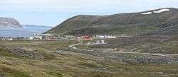
Kangiqsujuaq (Inuktitut: ᑲᖏᕐᓱᔪᐊᖅ) is a northern village (Inuit community) in Nunavik, Nord-du-Québec, Quebec, Canada. It had a population of 750 in the Canada 2016 Census. The community has also been known as Wakeham Bay. The name "Kangiqsujuaq" means "the large bay" in Inuktitut[5].
It is located on the Ungava Peninsula, on the Cap du Prince-de-Galles on the Hudson Strait. It is served by the small Kangiqsujuaq Airport.
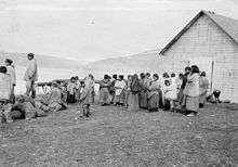
During winter, when the tides are extremely low, local Inuit sometimes climb beneath the shifting sea ice to gather blue mussels. They break holes in the ice and then can walk for a short time on the exposed sea bed and collect this food. This risky way of gathering the mussels goes back for generations.[6]
As the other villages of the Kativik region, the Kativik Regional Police Force provides police services in Kangiqsujuaq[7].
Kangiqsujuaq is the closest community to the Qajartalik archaeological site, a site featuring petroglyphs created by the Dorset culture.[8] In 2017, it was announced that the Qajartalik would be added to Canada's tentative list for nomination to the UNESCO World Heritage Site list.[9]
Education
The Kativik School Board operates the Arsaniq School.[10]
References
- 1 2 3 Geographic code 99130 in the official Répertoire des municipalités (in French)
- ↑ Reference number 98662 of the Commission de toponymie du Québec (in French)
- ↑ "(Code 2499130) Census Profile". 2011 census. Statistics Canada. 2012.
- ↑ https://www12.statcan.gc.ca/census-recensement/2016/dp-pd/prof/details/page.cfm?Lang=E&Geo1=CSD&Code1=2499130&Geo2=CD&Code2=2499&Data=Count&SearchText=Kangiqsujuaq&SearchType=Begins&SearchPR=01&B1=All&TABID=1
- ↑ "Kangiqsujuaq - Community in Nunavik, Northern Arctic Quebec". www.nunavik-tourism.com. Retrieved 2017-07-03.
- ↑ "Inuit's risky mussel harvest under sea ice". BBC News. 25 January 2011. Retrieved 25 January 2011.
- ↑ KRPF. "General Information". Home. Retrieved 2017-07-03.
- ↑ "Protection and development of the Qajartalik petroglyph site (JhEv-1)". Avataq Cultural Institute. Avataq Cultural Institute. Retrieved 9 June 2018.
- ↑ "Canada puts forward 8 UNESCO recommendations". CBC News. 20 December 2018. Retrieved 17 May 2018.
- ↑ "Our Schools." Kativik School Board. Retrieved on September 23, 2017.
External links
| Wikimedia Commons has media related to Kangiqsujuaq. |
- Official Site (English version)
- If the Weather Permits, a documentary about life in Kangiqsujuaq.
- Video of mussel gathering