Kamenný Most (Kladno District)
| Kamenný Most | |||
|---|---|---|---|
| Municipality and village | |||
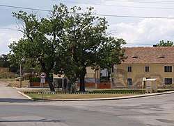 Center of the village | |||
| |||
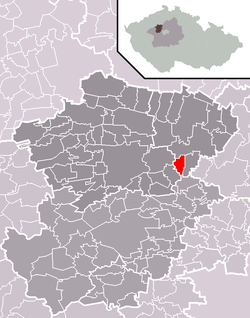 | |||
 Kamenný Most Location in the Czech Republic | |||
| Coordinates: 50°14′N 14°13′E / 50.233°N 14.217°ECoordinates: 50°14′N 14°13′E / 50.233°N 14.217°E | |||
| Country |
| ||
| Region | Central Bohemian Region | ||
| District | Kladno District | ||
| Area | |||
| • Total | 1.26 sq mi (3.27 km2) | ||
| Elevation | 700 ft (200 m) | ||
| Population (2011) | |||
| • Total | 410 | ||
| • Density | 320/sq mi (130/km2) | ||
| Time zone | UTC+1 (CET) | ||
| • Summer (DST) | UTC+2 (CEST) | ||
_vlajka.jpg)
_znak.jpg)
Kamenný Most is a village and municipality in Kladno District in the Central Bohemian Region of the Czech Republic.
History
The village was first mentioned in 1088. According to legend, a path led through the village from the Prague royal seat to Stadice. West of the village on a hill stands a 120 centimetres (3.9 ft) tall sandstone engraving of a Latin cross, which is considered to be a Celtic cult object known as a menhir.[1]
References
| Wikimedia Commons has media related to Kamenný Most (Kladno District). |
- This article was initially translated from the Czech Wikipedia.
This article is issued from
Wikipedia.
The text is licensed under Creative Commons - Attribution - Sharealike.
Additional terms may apply for the media files.