Kamakura Valley
| Kamakura Valley | |
|---|---|
| 鎌倉峡 | |
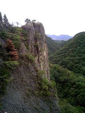 Hyakujo Rock at Kamakura Valley
(September 2008) | |
| Highest point | |
| Elevation | 292.2 m (959 ft) (Hyakujo Rock) |
| Coordinates | 34°51′17″N 135°15′22″E / 34.85472°N 135.25611°E |
| Naming | |
| Pronunciation | Japanese: [kamakɯɾa kʲoː] |
| Geography | |
| Location | Nishinomiya, Hyōgo, Japan |
| Parent range | Rokko Mountains |
The Kamakurakyo (鎌倉峡 Kamakura-kyō) is a geographical area that is located in the Rokko Mountains, Hyōgo, Japan. This valley is a part of Setonaikai National Park in Japan.
History
The name of Kamakura Valley originated in a historical episode that in the 13th century, Hōjō Tokiyori, one of Shikken, namely the regent for the shogun in the Kamakura shogunate, visited this valley and praised the beauty.
Geography
This valley is along Funazaka River, which is a branch of the Muko River. The length of the valley is about two kilometers. This valley was made by the river invaded liparite, so we can see high stone wall of liparite along the river.This valley has the famous Hyakujo Rock as the rand mark and a popular rock climbing spot of this region.
Route
Gallery
- Hyakujoiwa Rock from south (September 2008)
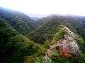 A View from Hyakujoiwa (1) (September 2008)
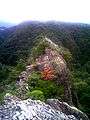 A View from Hyakujoiwa (2) (September 2008)
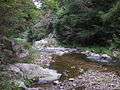 A scene of Kamakura Valley (September 2008)
References
| Wikimedia Commons has media related to Kamakurakyo. |
This article is issued from
Wikipedia.
The text is licensed under Creative Commons - Attribution - Sharealike.
Additional terms may apply for the media files.