Kaltenbach (Mangfall)
| Kaltenbach | |
|---|---|
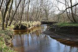 The Kaltenbach at Kolbermoor | |
| Country | Germany |
| States | Bavaria |
| Physical characteristics | |
| River mouth |
Mangfall 47°50′41″N 12°07′27″E / 47.8448°N 12.1241°ECoordinates: 47°50′41″N 12°07′27″E / 47.8448°N 12.1241°E |
| Length | 29.9 km (18.6 mi) [1] |
| Basin features | |
| Progression | Mangfall→ Inn→ Danube→ Black Sea |
| Basin size | 112 km2 (43 sq mi) [1] |
Kaltenbach is a river of Bavaria, Germany. It is a right tributary of the Mangfall at Rosenheim.[2]
See also
| Wikimedia Commons has media related to Kaltenbach (Mangfall). |
References
- 1 2 Complete table of the Bavarian Waterbody Register by the Bavarian State Office for the Environment (xls, 10.3 MB)
- ↑ Google (3 May 2018). "Kaltenbach" (Map). Google Maps. Google. Retrieved 3 May 2018.
This article is issued from
Wikipedia.
The text is licensed under Creative Commons - Attribution - Sharealike.
Additional terms may apply for the media files.