Kalpati
 Kalpatti Island | |
| Geography | |
|---|---|
| Location | Arabian Sea |
| Coordinates | 10°48′47″N 72°10′01″E / 10.813°N 72.167°ECoordinates: 10°48′47″N 72°10′01″E / 10.813°N 72.167°E |
| Archipelago | Lakshadweep |
| Adjacent bodies of water | Indian Ocean |
| Total islands | 1 |
| Major islands |
|
| Area | 0.085 km2 (0.033 sq mi)[1] |
| Length | 0.4 km (0.25 mi) |
| Width | 0.25 km (0.155 mi) |
| Coastline | 1.5 km (0.93 mi) |
| Highest elevation | 1 m (3 ft) |
| Administration | |
| Territory | Union territory of Lakshadweep |
| District | Lakshadweep |
| Island group | Laccadive Islands |
| Tehsils of India | Kavaratti |
| Subdivisions of India | Agatti Island |
| Largest settlement | (None) |
| Demographics | |
| Population | 0 (2017) |
| Pop. density | 0 /km2 (0 /sq mi) |
| Ethnic groups | (None) |
| Additional information | |
| Time zone | |
| PIN | 68255x |
| Telephone code | 0489x |
| ISO code | IN-LD-06[2] |
| Official website |
www |
| Avg. summer temperature | 32.0 °C (89.6 °F) |
| Avg. winter temperature | 28.0 °C (82.4 °F) |
| Sex ratio | 0♂/♀ |
Kalpatti Island is an uninhabited island of Agatti atoll in Lakshadweep, India. There were plans to extend the runway of the airport on the nearby Agatti Island to Kalpati Island to accommodate jet aircraft.[3] The plans were rejected on environmental grounds because the proposed runway extension would have passed a turtle colony.[4]
Administration
The island belongs to the township of Agatti Island of Kavaratti Tehsil.[5]
Image gallery
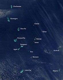 Satellite picture showing the atolls of the Lakshadweep except for Minicoy
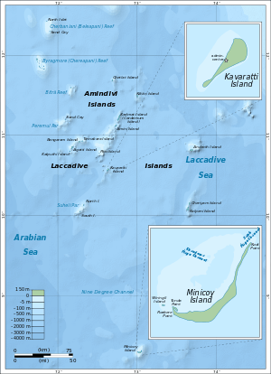 Map
Map
See also
References
- ↑ "Islandwise Area and Population - 2011 Census" (PDF). Government of Lakshadweep. Archived from the original (PDF) on 2016-07-22.
- ↑ Registration Plate Numbers added to ISO Code
- ↑ Sinha, Saurabh (February 15, 2007). "Airport across two islands in Lakshadweep". Times Of India. Retrieved 26 February 2014.
- ↑ Sinha, Saurabh (February 6, 2013). "Bridge on sea to extend Lakshadweep airport runway". Times of India. Retrieved 26 February 2014.
- ↑ Tehsils info
This article is issued from
Wikipedia.
The text is licensed under Creative Commons - Attribution - Sharealike.
Additional terms may apply for the media files.