Kalce, Logatec
| Kalce | |
|---|---|
 | |
 Kalce Location in Slovenia | |
| Coordinates: 45°53′41.4″N 14°11′23.37″E / 45.894833°N 14.1898250°ECoordinates: 45°53′41.4″N 14°11′23.37″E / 45.894833°N 14.1898250°E | |
| Country |
|
| Traditional region | Inner Carniola |
| Statistical region | Central Slovenia |
| Municipality | Logatec |
| Area | |
| • Total | 15.24 km2 (5.88 sq mi) |
| Elevation | 490.9 m (1,610.6 ft) |
| Population (2002) | |
| • Total | 320 |
| [1] | |
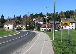
Kalce (pronounced [ˈkau̯ːtsɛ]) is a settlement southwest of Logatec in the Inner Carniola region of Slovenia.[2]
Cultural heritage
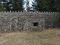
Near the village is the Lanišče Roman fortress, a restored part of the Roman Claustra Alpium Iuliarum system of northern defence walls and fortresses. Archaeological excavations in the 1960s determined that it was in use in the late 4th century AD and was probably destroyed during the war between Magnus Maximus and Theodosius in 388.[3]
Mass grave
Kalce is the site of a mass grave associated with the Second World War. The Repiše Shaft Mass Grave (Slovene: Grobišče Brezno na Repišah) is located in a shaft with a small entrance southeast of the settlement. The remains of two unknown victims were discovered in the shaft, covered by a large amount of rock that had been thrown in.[4]
Church
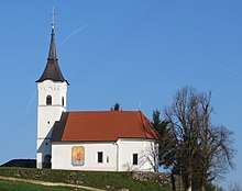
The church in Kalce is dedicated to John the Evangelist. It was first mentioned in written records in 1526.[5] There is a fresco depicting Saint Christopher on the exterior south wall.
References
- ↑ Statistical Office of the Republic of Slovenia
- ↑ Logatec municipal site
- ↑ Visit Ljubljana site
- ↑ Repiše Shaft Mass Grave on Geopedia (in Slovene)
- ↑ "Logatec – Cerkev sv. Janeza Evangelista". Občina Logatec. Retrieved April 22, 2018.
External links
| Wikimedia Commons has media related to Kalce, Logatec. |
- Kalce on Geopedia
- Lanišče: surround photography. Burger.si.
| Settlements | Administrative centre: Logatec
|  | ||||
|---|---|---|---|---|---|---|
| Landmarks |
| |||||