Kai Tak Nullah
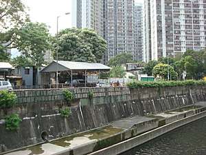
The Kai Tak Nullah (Chinese: 啟德明渠, also known as the Kaitak River (啟德河)) is a nullah or watercourse that collects water from the rivers and streams flowing from the hills in northern New Kowloon. It empties into a narrow channel leading into the Kwun Tong Typhoon Shelter. Part of the nullah is covered by roads and other facilities.
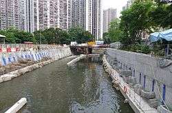
The Kai Tak Nullah is about 2.4km in length. It flows from Po Kong Village Road along Choi Hung Road, pass Tung Tau Estate and San Po Kong, into Kai Tak Development Area before discharging into the Victoria Harbour. They have an Upstream and a Midstream. The nullah is one of the major flood relief drainage channels in East Kowloon area.[1] The improvement work of Kai Tak Nullah has been undergoing by Civil Engineering and Development Department since March 2012, aiming to turn the nullah into an attractive green river corridor.[2] It is anticipated to be fully completed before 2021.
History
Originally, the place of Kai Tak Nullah was a bay. During Japanese occupation, Kai Tak Airport was expanded through land reclamation. The extension of Fung Wong Kai Stream was named as Lung Tsun River龍津河.Lung Tsun River's original estuary is at the north of To Kwa Wan Road. But after the airport expansion work, the reclamation for runway blocked estuary and the river was redirected into today's route.
During New Territories new town development in 1970s, river become a nullah for Tai Po Sewage Treatment Works, The Shatin Sewage Treatment Works and illegal discharge pollutants. This results pollutants and heavy pollutants in water, which also causes smell issue. After the treatment work done by the Drainage Services Department, the Kai Tak Nullah has been significant improvement since 2000. Ardeidae is seen beside the nullah.
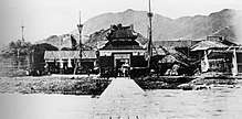 Kai Tak Nullah was a bay, closed to Lung Tsun Stone Bridge(1915)
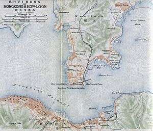 Map of Kolwoon in 1915. The Kai Tak Nullah is next to Kowloon Walled City(or Chinese Town in this map)and Lung Tsun Stone Bridge.
 Kai Tak Nullah in 1960
 Water flow from Nullah to Kai Tak Airport in 2007
 Meeting point of Fung Wong Kai Stream and Kai Tak Nullah(2008)
Proposal of covering nullahs
On January 2005, Drainage Services Department announced a nullah-covering works for 16 nullahs, at the cost of 1.2 billion Hong Kong dollars. It was planned to cover up part of the Kai Tak Nullahs along Choi Hung Road, starting from 2010 and completing by 2014. The Traffic and Transport Committee of Wong Tai Sin District Council demand for acceleration, in order to launch the greening work and widen the Choi Hung Road.
Yet, as the water quality improved, plus the request from the pro-Beijing political party Democratic Alliance for the Betterment and Progress, Federation of Trade Unions and environment concern group Conservancy Association, the Civil Engineering and Development Department launched afeasibility study on turning nullah into Kai Tak River.[3][4] They aim to turn it into a new river like the Cheonggyecheon in South Korea.[5]
See also
| Wikimedia Commons has media related to Kai Tak Nullah. |
Coordinates: 22°19′47″N 114°11′52″E / 22.3298°N 114.1977°E
References
- ↑ http://www.ktd.gov.hk/kaitakriver/eng/existingkaitaknullah.html
- ↑ "Public Engagement for Building our KaiTak River-Vision". Retrieved 21 August 2016.
- ↑ 啟德明渠恐難成「河」 水量水質成隱憂 Archived 2012-07-12 at Archive.is《明報》,2007年8月17日
- ↑ Conservancy Association and Legislation Councilor Chan Yuen-han proposed to government an "Urban Eco-river" in San Po Kong,gave the nullahs a new name as Kai Tak River. Details refers to 啟德河網誌
- ↑ 啟德明渠有望變清溪生態園 600米河道 料免全面覆蓋。參見 600米河道 料免全面覆蓋 Archived 2012-07-09 at Archive.is《明報》,2008年2月16日