Billings, Ontario
| Billings | |
|---|---|
| Township (single-tier) | |
| Township of Billings | |
 | |
 Billings | |
| Coordinates: 45°54′N 82°15′W / 45.900°N 82.250°WCoordinates: 45°54′N 82°15′W / 45.900°N 82.250°W | |
| Country |
|
| Province |
|
| District | Manitoulin |
| Incorporated | 1884 |
| Government | |
| • Type | Township |
| • Reeve | Austin Hunt |
| • MP | Carol Hughes (NDP) |
| • MPP | Michael Mantha (NDP) |
| Area[1] | |
| • Land | 209.30 km2 (80.81 sq mi) |
| Population (2011)[1] | |
| • Total | 506 |
| • Density | 2.4/km2 (6/sq mi) |
| Time zone | UTC-5 (EST) |
| • Summer (DST) | UTC-4 (EDT) |
| Postal code | P0P 1J0 |
| Area code(s) | 705 |
| Website |
www |
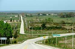
Billings is a township in the Canadian province of Ontario, as well as the name of a community within that township.
Located in the Manitoulin District, the township had a population of 506 in the Canada 2011 Census.
Communities
The primary community in the township is Kagawong. There are three smaller communities: Billings, Bowser's Corner, and Pleasant Valley.
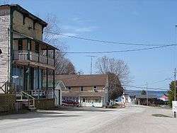
Kagawong
Kagawong's harbour is located on Mudge Bay and is home to the Kagawong Lighthouse, which has been in continuous service since 1888. The name Kagawong means "where mists rise from falling waters" in the Ojibwe language, a reference to the nearby Bridal Veil Falls on the Kagawong River.
Kagawong is home to numerous tourist attractions. The most popular being the famed Bridal Veil Falls. The legend is that those who swim under the falls are rewarded with good luck. The falls begin at the end of the upper Kagawong river, and flow past a series of small, cascading waterfalls down a winding trail towards Mudge Bay. The trails are spotted with art pieces, benches and picnic tables. In addition to the falls, Kagawong is also home to a Transportation and Communication Museum, Art Gallary, Anglican Church, several sandy beaches, and many camping and cottage rental opportunities.
Kagawong is the nearest port of call to the islands of the North Channel, being directly south of Clapperton Island and the Benjamin Islands.
Demographics
| Canada census – Billings, Ontario community profile | |||
|---|---|---|---|
| 2011 | 2006 | ||
| Population: | 506 (-6.1% from 2006) | 539 (-2.2% from 2001) | |
| Land area: | 209.30 km2 (80.81 sq mi) | 209.15 km2 (80.75 sq mi) | |
| Population density: | 2.4/km2 (6.2/sq mi) | 2.6/km2 (6.7/sq mi) | |
| Median age: | 53.6 (M: 53.6, F: 53.5) | ||
| Total private dwellings: | 704 | 618 | |
| Median household income: | $42,733 | ||
| References: 2011[2] 2006[3] earlier[4] | |||
See also
References
- 1 2 "Billings census profile". 2011 Census of Population. Statistics Canada. Retrieved 2012-02-24.
- ↑ "2011 Community Profiles". Canada 2011 Census. Statistics Canada. July 5, 2013. Retrieved 2012-02-24.
- ↑ "2006 Community Profiles". Canada 2006 Census. Statistics Canada. March 30, 2011. Retrieved 2012-02-24.
- ↑ "2001 Community Profiles". Canada 2001 Census. Statistics Canada. February 17, 2012.
External links
| Wikimedia Commons has media related to Billings, Ontario. |
Places adjacent to Billings, Ontario | |
|---|---|