Kańczuga
| Kańczuga | ||
|---|---|---|
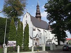 Archangel Michael Church | ||
| ||
 Kańczuga | ||
| Coordinates: 50°0′N 22°24′E / 50.000°N 22.400°E | ||
| Country |
| |
| Voivodeship |
| |
| County | Przeworsk | |
| Gmina | Kańczuga | |
| Government | ||
| • Mayor | Jacek Sołek | |
| Area | ||
| • Total | 7.61 km2 (2.94 sq mi) | |
| Elevation | 220 m (720 ft) | |
| Population (2006) | ||
| • Total | 3,211 | |
| • Density | 420/km2 (1,100/sq mi) | |
| Time zone | UTC+1 (CET) | |
| • Summer (DST) | UTC+2 (CEST) | |
| Postal code | 37-220 | |
| Car plates | RPZ | |
| Website | http://www.kanczuga.pl | |

Kańczuga [kaɲˈt͡ʂuɡa] is a town in Przeworsk County, Subcarpathian Voivodeship, Poland, with a population of 3,187 inhabitants (02.06.2009).[1] The town was an early centre of the Polish automobile industry. Buses based on Fiat 621R and used in Kraków had bodywork fitted in Kańczuga. Today the town is known for restoration of old SAABs.[2]
History
Kańczuga was first mentioned in documents from 1340, when it was part of Red Ruthenia. At that time, the village belonged to the noble Pilecki family. In the second half of the 14th century, Elżbieta Pilecka, the daughter of Kańczuga’s founder Otton of Pilcza, married a nobleman from Greater Poland, Wincenty Granowski, and after his death, she married King Wladyslaw Jagiello.
In 1440, Kańczuga received town charter. It still remained in the hands of the Pilecki family, but in the subsequent centuries, Kańczuga was property of such families, as Odrowaz, Kostka, Ostrogski, Lubomirski and Sanguszko. The town, with its deep tunnels used as merchant goods storages, prospered until the late 15th century, when its population reached 3000. In 1498, Kańczuga was burned to the ground in a Wallachian raid, which ended the period of prosperity. In the 16th and early 17th centuries, the area of Kańczuga was frequently raided by the Crimean Tatars. In a 1624 raid, all local villages were burned, and thousands of residents kidnapped.
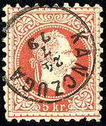
As a result of the first of Partitions of Poland (Treaty of St-Petersburg dated 5 July 1772), Kańczuga was attributed to the Habsburg Monarchy as part of Austrian Galicia, in which it remained until 1918.[3] When a postoffice was opened in 1870, the town was in the Przeworsk Bezirkshauptmannschaft.
For more details, see the article Kingdom of Galicia and Lodomeria.
References
- Notes
- ↑ "Population. Size and structure by territorial division" (PDF). © 1995-2009 Central Statistical Office 00-925 Warsaw, Al. Niepodległości 208. 2009-06-02. Archived from the original (PDF) on 2011-09-26. Retrieved 2009-06-22. External link in
|publisher=(help) - ↑ „Automobilista” Nr 81 12/2006 Archived 2007-09-28 at the Wayback Machine.
- ↑ Atlas des peuples d'Europe centrale, André et Jean Sellier, 1991, p.88
External links
- Official town webpage
- Witryna o mieście i gminie Kańczuga
- Kanczuga.org - Virtually re-building Jewish Kańczuga
Coordinates: 49°59′02″N 22°24′31″E / 49.98389°N 22.40861°E