Kōrakuen Station
 .png) Kōrakuen Station 後楽園駅 | |
|---|---|
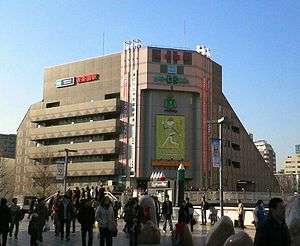 Korakuen Station exterior, March 2006 | |
| Location |
1-2-3 Kasuga, Bunkyō, Tokyo (東京都文京区春日1-2-3) Japan |
| Operated by | Tokyo Metro |
| Line(s) | |
| Other information | |
| Station code | M-22, N-11 |
| History | |
| Opened | 1954 |
Kōrakuen Station (後楽園駅 Kōrakuen-eki) is a subway train station in Bunkyō, Tokyo, Japan, operated by the Tokyo subway operator Tokyo Metro. It is directly connected by an underground pedestrian passage to the Toei-operated Kasuga Station. It is integrated with the Tokyo Dome City complex and the Bunkyō ward capitol building.
Lines
Kōrakuen Station is served by the following lines:
- Tokyo Metro Marunouchi Line, station number M-22
- Tokyo Metro Namboku Line, station number N-11
Nearby Kasuga Station, connected by a pedestrian passageway, is served by the following lines.
- Toei Mita Line, station number I-12
- Toei Ōedo Line, station number E-07
Layout
The Marunouchi Line platforms (1 to 2) consist of two side platforms serving two tracks on the second-floor ("2F") level, and the Namboku Line platforms (3 to 4) consist of an island platform serving two deep-level tracks on the sixth basement ("B6F") level.
Platforms
| 1 | ■ Tokyo Metro Marunouchi Line | for Tokyo and Ogikubo |
| 2 | ■ Tokyo Metro Marunouchi Line | for Ikebukuro |
| 3 | ■ Tokyo Metro Namboku Line | for Akabane-iwabuchi |
| 4 | ■ Tokyo Metro Namboku Line | for Meguro |
From March 2015, the Namboku Line platforms use the tune "Take Me Out to the Ball Game" as the departure melody, chosen as the nearby Tokyo Dome is used for baseball games.[1]
Adjacent stations
| Preceding station | Tokyo Metro | Following station | ||
|---|---|---|---|---|
M23 toward Ikebukuro | Marunouchi Line | M21 toward Ogikubo |
||
N10 toward Meguro | Namboku Line | N12 toward Akabane-iwabuchi |
History
Kōrakuen Station opened on 20 January 1954 on the Marunouchi Line.[2] The Namboku Line platforms opened on 26 March 1996.[2]
From 13 March 2015, the tune "Take Me Out to the Ball Game" was used as the departure melody for the Namboku Line platforms.[1]
Surrounding area
- Bunkyo Civic Center
- Tokyo Dome City entertainment complex
- Tokyo Dome baseball stadium
- Koishikawa Kōrakuen Garden
- Several train stations nearby:
- Kasuga Station (Toei)
- Suidōbashi Station (JR East, Toei)
References
- 1 2 南北線の発車メロディをリニューアル!各駅に新しい発車メロディを導入します [Namboku Line departure melodies updated! New melodies to be introduced at each station] (PDF). News release (in Japanese). Japan: Tokyo Metro. 2 March 2015. Retrieved 6 March 2015.
- 1 2 Terada, Hirokazu (19 January 2013). データブック日本の私鉄 [Databook: Japan's Private Railways]. Japan: Neko Publishing. pp. 214–216. ISBN 978-4-7770-1336-4.
External links
| Wikimedia Commons has media related to Korakuen Station. |
- Korakuen Station information (Tokyo Metro) (in Japanese)
Coordinates: 35°42′26″N 139°45′05″E / 35.70734°N 139.751303°E