Kürnach
| Kürnach | ||
|---|---|---|
| ||
 Kürnach Location of Kürnach within Würzburg district 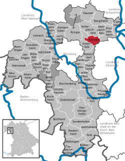 | ||
| Coordinates: 49°51′N 10°2′E / 49.850°N 10.033°ECoordinates: 49°51′N 10°2′E / 49.850°N 10.033°E | ||
| Country | Germany | |
| State | Bavaria | |
| Admin. region | Unterfranken | |
| District | Würzburg | |
| Government | ||
| • Mayor | Thomas Ebert (CSU) | |
| Area | ||
| • Total | 12.29 km2 (4.75 sq mi) | |
| Elevation | 268 m (879 ft) | |
| Population (2017-12-31)[1] | ||
| • Total | 4,831 | |
| • Density | 390/km2 (1,000/sq mi) | |
| Time zone | CET/CEST (UTC+1/+2) | |
| Postal codes | 97273 | |
| Dialling codes | 09367 | |
| Vehicle registration | WÜ | |
| Website | www.kuernach.de | |

Kürnach is a municipality in the district of Würzburg in Bavaria in Germany. The distance from Kürnach to the state capital of Bavaria München is about 221 km (137.6 miles). [2]
Population
Population of the municipality increased from 1904 to 2015.
| Years | The number of inhibitants | Sources |
|---|---|---|
| 1904 | 1237 inhabitants | [3] |
| 1950 | 1291 inhabitants | |
| 1970 | 1754 inhabitants | [4] |
| 1987 | 2849 inhabitants | |
| 1991 | 3020 inhabitants | |
| 1995 | 3539 inhabitants | |
| 2000 | 3991 inhabitants | |
| 2005 | 4387 inhabitants | |
| 2010 | 4466 inhabitants | |
| 2015 | 4796 inhabitants |
Gallery

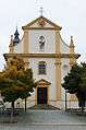
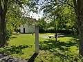
St Michael's Parish Church
References
- ↑ "Fortschreibung des Bevölkerungsstandes". Bayerisches Landesamt für Statistik und Datenverarbeitung (in German). September 2018.
- ↑ AM. "Municipality Kürnach - Informationen about Kürnach - Places-in-Germany.com". www.places-in-germany.com. Retrieved 2018-03-11.
- ↑ "Digitale Bibliothek - Münchener Digitalisierungszentrum". daten.digitale-sammlungen.de (in German). Retrieved 2018-03-11.
- ↑ Kürnach, Gemeinde. "Gemeinde Kürnach - Zahlen, Daten, Fakten". www.kuernach.de. Retrieved 2018-03-11.
This article is issued from
Wikipedia.
The text is licensed under Creative Commons - Attribution - Sharealike.
Additional terms may apply for the media files.