Körsch
| Körsch | |
|---|---|
 Course of the Körsch | |
| Country | Germany |
| States | Baden-Württemberg |
| Physical characteristics | |
| River mouth |
Neckar 48°42′59″N 9°21′32″E / 48.7164°N 9.3588°ECoordinates: 48°42′59″N 9°21′32″E / 48.7164°N 9.3588°E |
| Length | 27.5 km (17.1 mi) [1] |
| Basin features | |
| Progression | Neckar→ Rhine→ North Sea |
| Basin size | 128 km2 (49 sq mi) [1] |
![]()
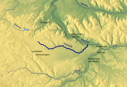
It is the second largest waterbody in Stuttgart and is formed at the convergence of the right Sindelbach and the left Aischbach in Stuttgart-Möhringen. After almost 27 km on the Filder it flows into the Neckar between Esslingen am Neckar and Deizisau.
See also
References
| Wikimedia Commons has media related to Körsch. |
- 1 2 Map services of the Baden-Württemberg State Office for the Environment, Survey and Conservation (Landesanstalt für Umwelt, Messungen und Naturschutz Baden-Württemberg)
- ↑ Google (6 April 2018). "Körsch" (Map). Google Maps. Google. Retrieved 6 April 2018.
This article is issued from
Wikipedia.
The text is licensed under Creative Commons - Attribution - Sharealike.
Additional terms may apply for the media files.