Königsberg, Bavaria
| Königsberg i.Bay. | ||
|---|---|---|
| ||
 Königsberg i.Bay. Location of Königsberg i.Bay. within Haßberge district 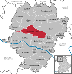 | ||
| Coordinates: 50°4′40″N 10°34′00″E / 50.07778°N 10.56667°ECoordinates: 50°4′40″N 10°34′00″E / 50.07778°N 10.56667°E | ||
| Country | Germany | |
| State | Bavaria | |
| Admin. region | Unterfranken | |
| District | Haßberge | |
| Government | ||
| • Mayor | Erich Stubenrauch | |
| Area | ||
| • Total | 61.86 km2 (23.88 sq mi) | |
| Elevation | 280 m (920 ft) | |
| Population (2017-12-31)[1] | ||
| • Total | 3,633 | |
| • Density | 59/km2 (150/sq mi) | |
| Time zone | CET/CEST (UTC+1/+2) | |
| Postal codes | 97486 | |
| Dialling codes | 09525 | |
| Vehicle registration | HAS | |
| Website | www.koenigsberg.de | |

Königsberg in Bayern is a town in the Haßberge district, in Lower Franconia, Bavaria, Germany. It is situated 7 km northeast of Haßfurt, and 31 km northwest of Bamberg.
The town is not to be confused with the most famous Königsberg in der Neumark (since 1945 as Chojna in Poland). It was an exclave of Saxe-Coburg and Gotha until 1918, after having been a part of Saxe-Hildburghausen.
People
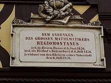
Plaque at the birthplace of Regiomontanus
- Johannes Müller alias Regiomontanus (6 June 1436 - 6 July 1476), famous mathematician and astronomer
- Johannes Marcellus (1510 - 25 December 1552), philologist and poet, also called Regiomontanus
- Friedrich Heinrich von Seckendorff, Imperial Fieldmarschall and Diplomat
- Wolfgang Carl Briegel, composer
References
- ↑ "Fortschreibung des Bevölkerungsstandes". Bayerisches Landesamt für Statistik und Datenverarbeitung (in German). September 2018.
Towns and municipalities in Haßberge (district) | ||
|---|---|---|
| Authority control |
|---|
This article is issued from
Wikipedia.
The text is licensed under Creative Commons - Attribution - Sharealike.
Additional terms may apply for the media files.