Käbelicksee
| Käbelicksee | |
|---|---|
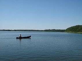 Käbelicksee, Müritz National Park, Germany | |
| Location | Mecklenburgische Seenplatte, Mecklenburg-Vorpommern |
| Coordinates | 53°25′2.31″N 12°56′33.29″E / 53.4173083°N 12.9425806°ECoordinates: 53°25′2.31″N 12°56′33.29″E / 53.4173083°N 12.9425806°E |
| Primary inflows | Havel |
| Primary outflows | Havel |
| Basin countries | Germany |
| Max. length | 2.51 km (1.56 mi) |
| Max. width | 1.508 km (0.937 mi) |
| Surface area | 2.64 km2 (1.02 sq mi) |
| Average depth | 3.4 m (11 ft) |
| Max. depth | 12.6 m (41 ft) |
| Water volume | 8,900,000 m3 (310,000,000 cu ft) |
| Shore length1 | 11.3 km (7.0 mi) |
| Surface elevation | 62.4 m (205 ft) |
| 1 Shore length is not a well-defined measure. | |
Käbelicksee is a lake in the Mecklenburgische Seenplatte district in Mecklenburg-Vorpommern, Germany.
It is part of the Müritz National Park. At an elevation of 62.4 m, its surface area is 2.64 km².
External links

- Nixdorf, B.; et al. (2004), "Käbelicksee", Dokumentation von Zustand und Entwicklung der wichtigsten Seen Deutschlands (in German), Berlin: Umweltbundesamt, p. 143
This article is issued from
Wikipedia.
The text is licensed under Creative Commons - Attribution - Sharealike.
Additional terms may apply for the media files.