Julier Pass
| Julier Pass | |
|---|---|
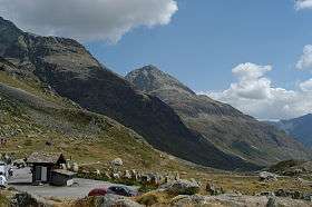 View towards the Engadin from the top of the Julier Pass | |
| Elevation | 2,284 m (7,493 ft) |
| Traversed by | Road |
| Location | Graubünden, Switzerland |
| Range | Alps |
| Coordinates | 46°28.32′N 09°43.74′E / 46.47200°N 9.72900°ECoordinates: 46°28.32′N 09°43.74′E / 46.47200°N 9.72900°E |
 Julier Pass Location in Switzerland | |
The Julier Pass (Romansh: Pass dal Güglia, German: Julierpass, Italian Passo del Giulia) (el. 2284 m) is a mountain pass in Switzerland, in the Albula Range of the Alps. It connects the Engadin valley with the rest of Graubünden. At its summit, the pass crosses the watershed / drainage divide between the basins of the Rivers Rhine and Danube. The Julier Pass lies between Piz Lagrev and Piz Julier.
Remains of a Roman temple and cart tracks were found and illustrate its importance in Roman times.
The road constructed in the 1820s to replace the old Septimer Pass was well built and is still easily passable after moderate widening for normal cars and trucks. In some parts, areas were rebuilt in 2009 to reduce the number of serpentine turns. Winter use requires winter tires, as well as snow chains in extremely poor weather.

Route
| Place | Elevation | Distance | Diff. elevation |
Total distance |
Total elevation diff. |
|---|---|---|---|---|---|
| Tiefencastel | 851 m | - | - | - | - |
| Savognin | 1207 m | 9 km | 356 m | 9 km | 356 m |
| Rona | 1408 m | 5 km | 201 m | 14 km | 557 m |
| Mulegns-Sur | 1538 m | 4.5 km | 130 m | 18.5 km | 687 m |
| Marmorera | 1680 m | 2.5 km | 142 m | 21 km | 829 m |
| Bivio | 1769 m | 5 km | 89 m | 27 km | 918 m |
| pass | 2284 m | 9 km | 515 m | 36 km | 1'433 m |
| Silvaplana | 1815 m | 7 km | - 469 m | 43 km | 964 m |
See also
External links