Johnston Atoll Airport
| Johnston Atoll Airport | |||||||||||
|---|---|---|---|---|---|---|---|---|---|---|---|
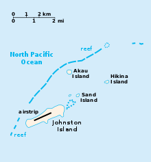 Map of the islands of Johnston Atoll, showing airstrip on Johnston Island | |||||||||||
| Summary | |||||||||||
| Airport type | Public | ||||||||||
| Location | Johnston Atoll | ||||||||||
| Elevation AMSL |
| ||||||||||
| Coordinates | 16°43′43″N 169°32′03″W / 16.72861°N 169.53417°WCoordinates: 16°43′43″N 169°32′03″W / 16.72861°N 169.53417°W | ||||||||||
| Map | |||||||||||
 PJON Location in the Pacific Ocean | |||||||||||
| Runways | |||||||||||
| |||||||||||
|
Source:[1] | |||||||||||
Johnston Atoll Airport is located on the Johnston Atoll in the United States Minor Outlying Islands, in the Pacific Ocean 717 nautical miles (1328 kilometers) southwest of Hawaii. While an active U.S. military facility during the 20th century, the airport was shut down in 2005 and the runway is not maintained.
History
In September 1941 construction of an airfield on Johnston Island commenced. A 4,000 feet (1,200 m) by 500 feet (150 m) runway was built together with two 400-man barracks, two mess halls, a cold-storage building, an underground hospital, a fresh-water plant, shop buildings, and fuel storage. The runway was complete by December 7, 1941, though in December 1943 the 99th Naval Construction Battalion arrived at the atoll and proceeded to lengthen the runway to 6,000 feet (1,800 m).[2] The runway was subsequently lengthened and improved as the island was enlarged.
During WWII Johnston Atoll was used as a refueling base for submarines, and also as an aircraft refueling stop for American bombers transiting the Pacific Ocean, including the Boeing B-29 Enola Gay.[3] By 1944, the atoll was one of the busiest air transport terminals in the Pacific. Air Transport Command aeromedical evacuation planes stopped at Johnston en route to Hawaii. Following V-J Day on August 14, 1945, Johnston Atoll saw the flow of men and aircraft that had been coming from the mainland into the Pacific turn around. By 1947, over 1,300 B-29 and B-24 bombers had passed through the Marianas, Kwajalein, Johnston Island, and Oahu en route to Mather Field and civilian life.
Continental Air Micronesia served the island commercially, touching down between Honolulu and Majuro. When an aircraft landed it was surrounded by armed soldiers and the passengers were not allowed to leave the aircraft. Aloha Airlines also made weekly scheduled flights to the island carrying civilian and military personnel, in the 1990s there were flights almost daily, and some days saw up to 3 arrivals.[4] Just prior to movement of the chemical munitions to Johnston Atoll, the Surgeon General, Public Health Service, reviewed the shipment and the Johnston Atoll storage plans. His recommendations caused the Secretary of Defense in December 1970 to issue instructions suspending missile launches and all non-essential aircraft flights. As a result, Air Micronesia service was immediately discontinued, and missile firings were terminated with the exception of two 1975 satellite launches deemed critical to the islands mission.[5]
Incidences and current use
There were many times when the runway was needed for emergency landings for both civil and military aircraft. When the runway was decommissioned, it could no longer be used as a potential emergency landing place for planning purposes when planning flight routes across the Pacific Ocean. As of 2003, the airfield at Johnston Atoll consisted of an unmaintained closed single 9,000 feet (2,700 m) asphalt/concrete runway 5/23, a parallel taxiway, and a large paved ramp along the south-east side of the runway.[4]
References
![]()
- ↑ Airport JOHNSTON ATOLL
- ↑ Building the Navy's Bases in World War II History of the Bureau of Yards and Docks and the Civil Engineer Corps 1940-1946. US Government Printing Office. 1947. pp. 158–9. ISBN 9781460943311.
- ↑ Norman Polmar (2004). The Enola Gay. Potomac Books, Inc. pp. 20–. ISBN 978-1-59797-506-3.
- 1 2 "Abandoned & Little-Known Airfields: Western Pacific Islands". Retrieved September 17, 2014.
- ↑ "Phase II Environmental Baseline Survey, Johnston Atoll, Appendix B" (PDF). Retrieved August 19, 2012.