Jichu Qullu (Tarucani)
| Jichu Qullu | |
|---|---|
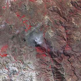 The Ubinas volcano and Jichu Qullu southwest of it (lower left) as seen from above (NASA, 2006) | |
| Highest point | |
| Elevation | 4,600 m (15,100 ft) [1] |
| Coordinates | 16°25′39″S 70°58′44″W / 16.42750°S 70.97889°WCoordinates: 16°25′39″S 70°58′44″W / 16.42750°S 70.97889°W |
| Geography | |
 Jichu Qullu Peru | |
| Location | Peru, Arequipa Region, Arequipa Province, Tarucani District |
| Parent range | Andes |
Jichu Qullu (Aymara jichu ichu, Peruvian feather grass, qullu mountain,[2] "ichu mountain", also spelled Ichocollo) is a mountain in the Andes of Peru which reaches a height of approximately 4,600 m (15,100 ft). It is located in the Arequipa Region, Arequipa Province, Tarucani District.[1]
References
- 1 2 escale.minedu.gob.pe - UGEL map of the Caylloma Province 2 (Arequipa Region)
- ↑ Radio San Gabriel, "Instituto Radiofonico de Promoción Aymara" (IRPA) 1993, Republicado por Instituto de las Lenguas y Literaturas Andinas-Amazónicas (ILLLA-A) 2011, Transcripción del Vocabulario de la Lengua Aymara, P. Ludovico Bertonio 1612 (Spanish-Aymara-Aymara-Spanish dictionary)
This article is issued from
Wikipedia.
The text is licensed under Creative Commons - Attribution - Sharealike.
Additional terms may apply for the media files.