Jermantown, Virginia
| Jermantown, Virginia | |
|---|---|
| Unincorporated community | |
 Jermantown  Jermantown  Jermantown | |
| Coordinates: 38°51′25″N 77°19′56″W / 38.85694°N 77.33222°WCoordinates: 38°51′25″N 77°19′56″W / 38.85694°N 77.33222°W | |
| Country | United States |
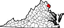
| State | Virginia |
| County | Fairfax |
| Time zone | UTC−5 (Eastern (EST)) |
| • Summer (DST) | UTC−4 (EDT) |
| GNIS feature ID | 1495006[1] |
Jermantown is an unincorporated community in Fairfax County, Virginia, United States. Various parts of Jermantown are included within the independent city of Fairfax to its south and east. Today, this once rural community is centered at the intersection of Jermantown Road and Lee Jackson Memorial Highway (U.S. Route 50). The Old Jermantown School [2] was located at the present site of Providence Elementary School.
History
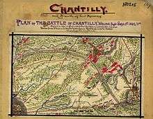
Map of Ox Hill battle
Jermantown/Germantown, located near the critical intersection of the Little River Turnpike (today Route 50) and Warrenton Turnpike (today Route 29), was part of the Ox Hill battlefield on September 1, 1862, and was held by Union troops under General Joseph Hooker.
References
This article is issued from
Wikipedia.
The text is licensed under Creative Commons - Attribution - Sharealike.
Additional terms may apply for the media files.