Burke Centre, Virginia
| Burke Centre, VA | |
|---|---|
| Census-designated place (CDP) | |
.jpg) Path in the woods, Burke Centre | |
| Nickname(s): Burke Centre | |
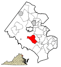 Burke, Fairfax County, Virginia. Burke Centre is the western part of the red area on this map. | |
 Burke Centre, VA  Burke Centre, VA Burke Centre, VA (Virginia)  Burke Centre, VA Burke Centre, VA (the US) | |
| Coordinates: 38°47′28″N 77°18′02″W / 38.79111°N 77.30056°WCoordinates: 38°47′28″N 77°18′02″W / 38.79111°N 77.30056°W | |
| Country | United States |
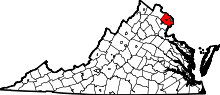
| State | Virginia |
| County | Fairfax |
| Area | |
| • Total | 3.16 sq mi (8.19 km2) |
| • Land | 3.12 sq mi (8.09 km2) |
| • Water | 0.04 sq mi (0.11 km2) |
| Elevation | 381 ft (116 m) |
| Population (2010) | |
| • Total | 17,326 |
| • Density | 5,549/sq mi (2,142.5/km2) |
| Time zone | UTC−5 (Eastern (EST)) |
| • Summer (DST) | UTC−4 (EDT) |
| ZIP codes | 22015 |
| Area code(s) | 703, 571 |
| FIPS code | 51-11470[1] |
| GNIS feature ID | 2584818[2] |
Burke Centre is a census-designated place (CDP) and planned residential community west of Burke, Fairfax County, Virginia, United States. As of the 2010 census, Burke Centre had a total population of 17,326.[3] Burke Centre Conservancy is a homeowners' association (HOA) to which all of Burke Centre belongs.
Burke Centre is located south of the center of Fairfax County. It is bordered to the east and partially to the north by the Burke CDP, and to the west and north by the Fairfax Station CDP.
References
- ↑ "American FactFinder". United States Census Bureau. Archived from the original on 2013-09-11. Retrieved 2008-01-31.
- ↑ "US Board on Geographic Names". United States Geological Survey. 2007-10-25. Retrieved 2008-01-31.
- ↑ "Geographic Identifiers: 2010 Demographic Profile Data (G001): Burke Centre CDP, Virginia". U.S. Census Bureau, American Factfinder. Retrieved September 22, 2016.
External links
| Wikimedia Commons has media related to Burke Centre, Virginia. |
Places adjacent to Burke Centre, Virginia | |
|---|---|
This article is issued from
Wikipedia.
The text is licensed under Creative Commons - Attribution - Sharealike.
Additional terms may apply for the media files.