Jerktail, Missouri
| Jerktail | |
|---|---|
| Unincorporated community | |
 Jerktail Location within the state of Missouri | |
| Coordinates: 37°25′27″N 92°26′13″W / 37.42417°N 92.43694°WCoordinates: 37°25′27″N 92°26′13″W / 37.42417°N 92.43694°W[1] | |
| Country | United States |
| State | Missouri |
| County | Wright |
| Elevation[1] | 1,306 ft (398 m) |
| Time zone | UTC-6 (Central (CST)) |
| • Summer (DST) | UTC-5 (EDT) |
| GNIS feature ID | 750505[1] |
Jerktail is an unincorporated community located in northern Wright County, Missouri, United States.[1] The community is about two miles west of the Gasconade River and about three miles south of Competition in adjacent Laclede County.[2]
Variant names were "Jerk Tail" and "Mint".[1] A post office called Mint was established in 1889, and remained in operation until 1910.[3] The former name "Mint" was due to the abundance of wild mint bushes near the original town site.[4]
References
- 1 2 3 4 5 U.S. Geological Survey Geographic Names Information System: Jerktail
- ↑ Missouri Atlas & Gazetteer, DeLorme, 1998, First edition, p. 53, ISBN 0-89933-224-2
- ↑ "Post Offices". Jim Forte Postal History. Retrieved 3 January 2017.
- ↑ "Wright County Place Names, 1928–1945". The State Historical Society of Missouri. Archived from the original on June 24, 2016. Retrieved January 3, 2017.
Municipalities and communities of Wright County, Missouri, United States | ||
|---|---|---|
| Cities | 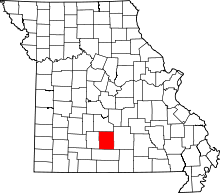 | |
| Townships | ||
| Unincorporated communities | ||
| Ghost towns | ||
| Footnotes | ‡This populated place also has portions in an adjacent county or counties | |
This article is issued from
Wikipedia.
The text is licensed under Creative Commons - Attribution - Sharealike.
Additional terms may apply for the media files.