Jawor
| Jawor | ||
|---|---|---|
 Town hall | ||
| ||
 Jawor | ||
| Coordinates: 51°03′N 16°12′E / 51.050°N 16.200°E | ||
| Country |
| |
| Voivodeship | Lower Silesian | |
| County | Jawor County | |
| Gmina | Jawor (urban gmina) | |
| Government | ||
| • Mayor | Emilian Bera | |
| Area | ||
| • Total | 18.8 km2 (7.3 sq mi) | |
| Population (2006) | ||
| • Total | 24,347 | |
| • Density | 1,300/km2 (3,400/sq mi) | |
| Time zone | UTC+1 (CET) | |
| • Summer (DST) | UTC+2 (CEST) | |
| Postal code | 59-400 | |
| Car plates | DJA | |
| Website | jawor.pl | |

Jawor [ˈjavɔr] (German: Jauer) is a town in south-western Poland with 24,347 inhabitants (2006). It is situated in Lower Silesian Voivodeship (from 1975–1998 it was in the former Legnica Voivodeship). It is the seat of Jawor County, and lies approximately 61 kilometres (38 mi) west of the regional capital Wrocław.
In the town can be found a Protestant Church of Peace. It was named a UNESCO World Heritage Site in 2001. Jawor Castle lies in Jawor.
The name Jawor is Polish for "sycamore". Prior to 1945, the town had a German majority. It had been part of Germany, Prussia, Austria, Bohemia, and Poland. After World War II the region was placed under Polish administration by the Potsdam Agreement under territorial changes demanded by the Soviet Union. Most of the German population of the town fled or were expelled and were replaced with Poles, some of whom had been expelled from the Polish areas annexed by the Soviet Union.
Notable residents
- Nicholas Magni (1355–1435), theologian
- Christoff Rudolff (1499-1545), author of the first German textbook on algebra
- Heinrich Gottfried von Mattuschka (1734–1779), German botanist
- Gerhard Bersu (1889-1964), German archeologist
- Max Otto Koischwitz (1902–1944), Nazi propagandist
- Heinz Finke (1920–1996), German officer
- Wilhelm Ebstein (1836-1912), doctor who described the heart disorder Ebstein's anomaly[1]
Gallery
 Church of Peace
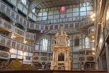 Church of Peace, interior
 Buildings in Jawor
 Jawor old market square
 Fresco in the church
References
- ↑ Mazurak M, Kusa J (2017). "The Two Anomalies of Wilhelm Ebstein". Tex. Heart. Inst. J. 44 (3): 198–201. doi:10.14503/THIJ-16-6063. PMC 5505398. PMID 28761400.
External links
- Official site
- Local flags
- Jewish Community in Jawor on Virtual Shtetl
- Church Of Peace in Jawor - photo gallery
| Wikimedia Commons has media related to Jawor. |
Coordinates: 51°03′N 16°12′E / 51.050°N 16.200°E
| Seat |
|  |
|---|---|---|
| Urban-rural gmina | ||
| Rural gminas | ||