Jarzé
| Jarzé | |
|---|---|
 Jarzé Location within Pays de la Loire region  Jarzé | |
| Coordinates: 47°33′22″N 0°13′55″W / 47.5561°N 0.2319°WCoordinates: 47°33′22″N 0°13′55″W / 47.5561°N 0.2319°W | |
| Country | France |
| Region | Pays de la Loire |
| Department | Maine-et-Loire |
| Arrondissement | Angers |
| Canton | Seiches-sur-le-Loir |
| Intercommunality | C.C. du Loir |
| Government | |
| • Mayor (2001–2008) | Elisabeth Marquet |
| Area1 | 33.12 km2 (12.79 sq mi) |
| Population (2006[1])2 | 1,489 |
| • Density | 45/km2 (120/sq mi) |
| Demonym(s) | Jarzéen, Jarzéenne |
| Time zone | UTC+1 (CET) |
| • Summer (DST) | UTC+2 (CEST) |
| INSEE/Postal code | 49163 /49140 |
| Elevation |
34–101 m (112–331 ft) (avg. 63 m or 207 ft) |
|
1 French Land Register data, which excludes lakes, ponds, glaciers > 1 km2 (0.386 sq mi or 247 acres) and river estuaries. 2 Population without double counting: residents of multiple communes (e.g., students and military personnel) only counted once. | |
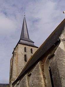
Belfry of the church of Sainte-Julitte
Jarzé (archaic Gercé, from Latin Gircea or Circea) is a former commune in the Maine-et-Loire department in western France. On 1 January 2016, it was merged into the new commune of Jarzé-Villages.[2]
References
- ↑ populations légales 2006 sur le site de l’INSEE
- ↑ Arrêté préfectoral Archived 2016-02-15 at the Wayback Machine. 18 December 2015
| Wikimedia Commons has media related to Jarzé. |
This article is issued from
Wikipedia.
The text is licensed under Creative Commons - Attribution - Sharealike.
Additional terms may apply for the media files.